
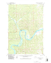
1954 Map of Sleetmute D-6
USGS Topo · Published 1961About this map
The Kuskokwim River defines the landscape of this interior Alaskan territory, dominated by the massive horseshoe curve known as the Great Bend. In the mid-1950s, the small settlement of Crooked Creek served as a key point of contact along the river, featuring a Gaging Sta, a Cem, and scattered Cabin clusters. Further downstream, the riverside community of Canoe Village (Aban's) sits tucked against the hills.
Find a feature on this map
23 named features on this map. Tap any name to fly to it.
Don’t see what you’re looking for? This feature index may not catch every label — zoom into the map to look around manually.
Map Details
Editions of this 1954 Sleetmute D-6 Map
2 editions found
Other maps of this area

1950 · Sleetmute
USGS Topo · 1:250,000

1951 · Iditarod
USGS Topo · 1:250,000

1954 · Sleetmute D-5
USGS Topo · 1:63,360
1954 · Sleetmute D-7
USGS Topo · 1:63,360

1954 · Iditarod A-5
USGS Topo · 1:63,360

1954 · Iditarod A-4
USGS Topo · 1:63,360

1954 · Sleetmute C-6
USGS Topo · 1:63,360

1954 · Sleetmute C-5
USGS Topo · 1:63,360

1954 · Sleetmute
USGS Topo · 1:250,000

1956 · Iditarod
USGS Topo · 1:250,000