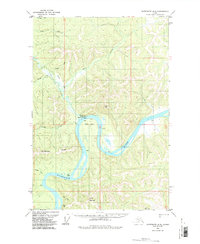
1954 Map of Sleetmute D-6
USGS Topo · Published 1987About this map
The Kuskokwim River defines the lower half of this mid-century interior landscape, carving a massive meander known as the Great Bend. Near the confluence of the river and Crooked Creek, the settlement of Crooked Creek serves as a focal point for the region, complete with a Landing Strip and Gaging Sta. This area represents a critical intersection of seasonal transportation and indigenous geography, where the Winter Trail cuts across the northern hills and Canoe Village sits on the southern bank of the river. The presence of a Cem near the primary settlement and scattered Cabin sites along the riverbanks highlights the localized footprint of residency and resource gathering. Terrain features like Oguohaydok Ridge and Canoe Mountain dominate the surrounding high ground, providing a sense of the formidable relief that shaped the routes between these remote outposts.
Find a feature on this map
30 named features on this map. Tap any name to fly to it.
Don’t see what you’re looking for? This feature index may not catch every label — zoom into the map to look around manually.
Map Details
Editions of this 1954 Sleetmute D-6 Map
2 editions found
Other maps of this area

1950 · Sleetmute
USGS Topo · 1:250,000

1951 · Iditarod
USGS Topo · 1:250,000

1954 · Sleetmute D-5
USGS Topo · 1:63,360

1954 · Sleetmute D-6
USGS Topo · 1:63,360
1954 · Sleetmute D-7
USGS Topo · 1:63,360

1954 · Iditarod A-5
USGS Topo · 1:63,360

1954 · Iditarod A-4
USGS Topo · 1:63,360

1954 · Sleetmute C-6
USGS Topo · 1:63,360

1954 · Sleetmute C-5
USGS Topo · 1:63,360

1954 · Sleetmute
USGS Topo · 1:250,000