
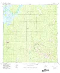
1954 Map of Iditarod A-5
USGS Topo · Published 1962About this map
Iditarod River meanders through the northwest corner of this interior Alaskan landscape, which reflects a mid-century period of mineral exploration and remote transport. The terrain is defined by complex drainage systems and ridges, notably around DeCourcy Mountain and Haystack Butte. Industrial activity is evident along Donlin Creek, where a Placer Mine and cabins are located near a specialized Landing Strip. Further west, the De Courcy Mtn Mine and its associated Landing Area mark another hub of activity, connected to the wider territory by a Tractor Trail. Evidence of earlier ventures appears in the form of Ruins and scattered cabin sites. The abundance of named gulches, such as Peary Gulch, Quartz Gulch, and Snow Gulch, suggests a landscape heavily scrutinized for its geological potential during this era of post-war mapping.
Find a feature on this map
33 named features on this map. Tap any name to fly to it.
Don’t see what you’re looking for? This feature index may not catch every label — zoom into the map to look around manually.
Map Details
Editions of this 1954 Iditarod A-5 Map
2 editions found
Other maps of this area

1950 · Sleetmute
USGS Topo · 1:250,000

1951 · Iditarod
USGS Topo · 1:250,000

1954 · Sleetmute D-6
USGS Topo · 1:63,360
1954 · Sleetmute D-7
USGS Topo · 1:63,360

1954 · Iditarod A-6
USGS Topo · 1:63,360

1954 · Iditarod A-4
USGS Topo · 1:63,360

1954 · Iditarod B-5
USGS Topo · 1:63,360

1954 · Iditarod B-4
USGS Topo · 1:63,360
1954 · Iditarod B-6
USGS Topo · 1:63,360

1954 · Sleetmute
USGS Topo · 1:250,000