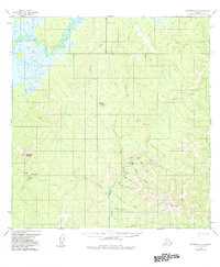
1954 Map of Iditarod A-5
USGS Topo · Published 1984About this map
The Iditarod River meanders through the northwest corner of this interior Alaskan landscape, which was being actively documented in the mid-1950s. The region is defined by its mining activity, most notably at the De Courcy Mtn Mine situated near the peaks of DeCourcy Mountain. This area reveals a remote infrastructure of remote Cabins and a Placer Mine along the Crooked watercourse, connected by a network of Tractor Trails and primitive Landing Strips that were essential for moving equipment and personnel across the tundra.
Find a feature on this map
34 named features on this map. Tap any name to fly to it.
Don’t see what you’re looking for? This feature index may not catch every label — zoom into the map to look around manually.
Map Details
Editions of this 1954 Iditarod A-5 Map
2 editions found
Other maps of this area

1950 · Sleetmute
USGS Topo · 1:250,000

1951 · Iditarod
USGS Topo · 1:250,000

1954 · Sleetmute D-6
USGS Topo · 1:63,360
1954 · Sleetmute D-7
USGS Topo · 1:63,360

1954 · Iditarod A-6
USGS Topo · 1:63,360

1954 · Iditarod A-5
USGS Topo · 1:63,360

1954 · Iditarod A-4
USGS Topo · 1:63,360

1954 · Iditarod B-5
USGS Topo · 1:63,360

1954 · Iditarod B-4
USGS Topo · 1:63,360
1954 · Iditarod B-6
USGS Topo · 1:63,360