
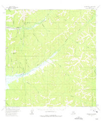
1954 Map of Iditarod B-4
USGS Topo · Published 1965About this map
Flat and Discovery anchor the northwestern corner of this interior Alaska landscape, reflecting the intense mining activity that defined the region during the mid-20th century. Numerous Placer Mine operations are scattered along the drainages of Otter Creek and Chicken Creek, illustrating the extensive search for gold across the drainage basins of Chicken Mtn. The reliance on seasonal travel and aviation in this roadless wilderness is evident through the network of a Summer Trail, a Winter Trail, and a remote Landing Strip. A lone Cabin along Bonanza Creek and various unnamed structures near the mines suggest a transient but active population of prospectors and laborers. The terrain is a dense network of waterways, including Moore Creek, Prince Creek, and Michigan Creek, which served as the primary routes for exploration and extraction in the Yukon-Koyukuk region.
Find a feature on this map
30 named features on this map. Tap any name to fly to it.
Don’t see what you’re looking for? This feature index may not catch every label — zoom into the map to look around manually.
Map Details
Editions of this 1954 Iditarod B-4 Map
2 editions found
Other maps of this area

1951 · Iditarod
USGS Topo · 1:250,000

1954 · Iditarod A-5
USGS Topo · 1:63,360

1954 · Iditarod C-4
USGS Topo · 1:63,360

1954 · Iditarod A-4
USGS Topo · 1:63,360

1954 · Iditarod B-5
USGS Topo · 1:63,360

1954 · Iditarod C-5
USGS Topo · 1:63,360

1954 · Iditarod A-3
USGS Topo · 1:63,360

1954 · Iditarod C-3
USGS Topo · 1:63,360

1954 · Iditarod B-3
USGS Topo · 1:63,360

1956 · Iditarod
USGS Topo · 1:250,000