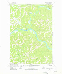
1954 Map of Sleetmute D-5
USGS Topo · Published 1976About this map
Georgetown sits at a strategic bend where the George River meets the Kuskokwim River, serving as a primary focal point for this interior Alaskan landscape. The mid-century survey reveals a river-centered economy and lifestyle, evidenced by the presence of Ruins and a lone Cabin further downstream. These small footprints of human activity are set against an intricate network of waterways, including Steamboat Creek and California Creek, which drain the surrounding high ground.
Find a feature on this map
12 named features on this map. Tap any name to fly to it.
Don’t see what you’re looking for? This feature index may not catch every label — zoom into the map to look around manually.
Map Details
Editions of this 1954 Sleetmute D-5 Map
2 editions found
Other maps of this area

1950 · Sleetmute
USGS Topo · 1:250,000

1951 · Iditarod
USGS Topo · 1:250,000

1954 · Sleetmute C-4
USGS Topo · 1:63,360

1954 · Sleetmute D-5
USGS Topo · 1:63,360

1954 · Sleetmute D-4
USGS Topo · 1:63,360

1954 · Sleetmute D-6
USGS Topo · 1:63,360

1954 · Iditarod A-4
USGS Topo · 1:63,360

1954 · Iditarod A-3
USGS Topo · 1:63,360

1954 · Sleetmute C-6
USGS Topo · 1:63,360

1954 · Sleetmute C-5
USGS Topo · 1:63,360