Old Maps of St. Michael, Alaska for Academic Research
Study the evolution of St. Michael with 12 high-resolution historic maps. Whether you're teaching, researching, or modeling changes in land use, these maps provide essential visual documentation of urban, environmental, and geographic change.
- Analyze long-term change: Track patterns in development, transportation, and natural features.
- Ideal for environmental or urban studies: Support academic projects with primary historical map data.
- Use in the classroom or lab: Educators and researchers rely on these maps to bring historical context to life.
These maps are a powerful tool for teaching, research, and visualizing how St. Michael has changed over the decades.
St. Michael, AK maps
(12)- 1951 Map of Unalakleet
 1951 Unalakleet1951 Print · USGSWestern Alaska's coastal and river corridors are captured in the early 1950s, showing the vital connection between Norton Sound and the interior. Researchers can trace the Winter Trail networks and locate remote outposts like Golsovia and the Coal Mine near Unalakleet.
 - 1951 Map of St Michael
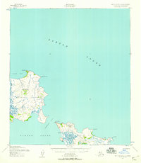
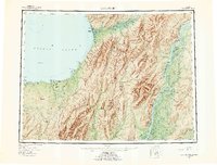
 1951 St Michael1951 Print · USGSCoastal Alaska at the mid-century reveals a world of remote outposts and intricate delta waterways. Researchers can trace the riverine geography of Kotlik, the settlement at St Michael, and traditional sites like Pastolik or Chaniliut along Norton Sound.
 - 1952 Map of Saint Michael C-1, 1958 Print
 1952 Saint Michael C-11958 Print · USGSThe remote coast of Norton Sound is captured here in the early fifties, showing the relationship between island settlements and the sea. Trace the old Trail near Stebbins or locate the Light at Cape Stephens and the seasonal Cabins.2 unique versions available
 - 1952 Map of Saint Michael B-1, 1958 Print
 1952 Saint Michael B-11958 Print · USGSSaint Michael was a vital Bering Sea port and administrative center in the early 1950s, captured here amidst a vast network of coastal canals and tundra. Researchers can trace the layout of the Saint Michael settlement, the U. S. School Reserve, and the historic Russian Gardens.2 unique versions available
 - 1952 Map of Unalakleet B-6, 1959 Print
 1952 Unalakleet B-61959 Print · USGSThe remote coastline of Norton Sound appears here in the early fifties, before modern expansion altered these subarctic outposts. Researchers can trace the Winter Trail past the Healy settlement or locate the Whale Island Light at the entrance to Liebes Cove.2 unique versions available
 - 1952 Map of St Michael, 1959 Print
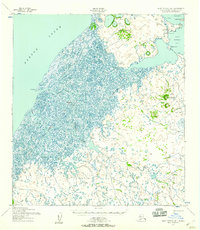
 1952 St Michael1959 Print · USGSThe northern Yukon-Kuskokwim Delta meets the sea in the early fifties, documenting a landscape of coastal villages and complex river passes. Researchers can trace the ancestral locations of Kotlik, Stebbins, and Nokogamiut alongside the historic ST MICHAEL TRAIL.4 unique versions available
 - 1952 Map of Unalakleet, 1960 Print
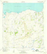
 1952 Unalakleet1960 Print · USGSWestern Alaska in the early fifties shows a landscape of coastal settlements and interior river networks. Researchers can trace the Winter Trail and locate sites like the Williams Mine or the village of Unalakleet at the edge of the sound.8 unique versions available
 - 1964 Map of St. Michael
 1964 St. Michael1964 Print · USGSCoastal settlements and the vast Yukon Delta waterways are charted here during the mid-1960s. Genealogists and historians can trace the locations of traditional villages like Kotlik, Nunaktuk, and Chaniliut along the Apoon Mouth.
 - 1964 Map of Unalakleet
 1964 Unalakleet1964 Print · USGSThe northern shores of Norton Sound and the interior Yukon River valley are documented here in the early sixties. Genealogists and researchers can trace remote outposts like Unalakleet, Golsovia, and the Williams Mine.
 - 2017 Map of Saint Michael C-1 SE, 2017 Print
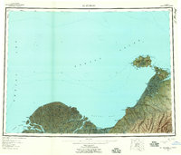
 2017 Saint Michael C-1 SE2017 Print · USGSCoastal communities in the Nome Census Area are documented here in the early twenty-first century. Researchers can trace the path of the Stebbins - Saint Michael Road between Stebbins and St. Michael, or locate landmarks like Stephens Hill.
 - 2017 Map of Saint Michael B-1 NE, 2017 Print
 2017 Saint Michael B-1 NE2017 Print · USGSThe coastal settlement of Saint Michael is captured here during the late twenty-teens, showing the unique intersection of the Norton Sound and the Alaskan tundra. Researchers can trace the local road network and identify landmarks like Saint Michael Mtn and the St. Michael Airport.
 - 2017 Map of Unalakleet B-6 NW, 2017 Print
 2017 Unalakleet B-6 NW2017 Print · USGSThe northern Alaskan coast near the Nome Census Area is documented here during the late twenty-teens. Researchers can examine the shoreline of Norton Sound and locate coastal features like St. Michael, Liebes Cove, and Fivemile Point.
End of results
Showing maps 1-12 of 12
Top cities near St. Michael
Top neighborhoods of St. Michael
Frequently asked questions
- What are the different types of historical maps available for St. Michael?
- What is the oldest map of St. Michael?
- Where can I purchase historical maps of St. Michael for my home or office?
- Where can I download high-res historical maps of St. Michael?
- Are there historical topographic maps available for St. Michael?
- Is there historical aerial imagery available for St. Michael?
- Where are historical maps of St. Michael sourced from?