1950s Maps of Stevens Village, Alaska
Explore 3 historic maps of Stevens Village from the 1950s. These maps offer a rare glimpse into what life looked like during the 1950s — showing old roads, neighborhoods, homes, and landmarks that have changed or disappeared over time.
Whether you're researching your family's past, planning a metal detecting trip, or studying how Stevens Village's landscape evolved across the 1950s, these high-resolution maps are a powerful tool for exploring the history of this region.
- Focus on a specific era: All maps on this page are from the 1950s, giving you a focused view of this time period.
- See what’s changed: Compare century-old streets, trails, and buildings to today's modern landscape using overlays and satellite layers.
- Research with precision: Use these maps for genealogy, historical research, land use analysis, or educational projects.
- View, download, or print: Maps are fully viewable online in high resolution, and can be downloaded or printed for your own records.
Start exploring Stevens Village's history through authentic maps from the 1950s. This is your window into the past.
Stevens Village, AK maps
(3)- 1951 Map of Beaver, 1952 Print
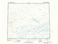 1951 Beaver1952 Print · USGSThe Alaska interior at the start of the 1950s reveals a wild landscape of river-based settlements and isolated outposts. Trace the remote life along the Yukon River through the Beaver Flats, locating Beaver, the airfield at Stevens, and the site of Purgatory (Aban'd).
 - 1956 Map of Beaver A-5, 1959 Print
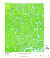 1956 Beaver A-51959 Print · USGSThe Yukon River flows past Stevens Village in the mid-1950s, a period when river travel and seasonal trails defined life in the interior. Genealogists and researchers can trace the footprint of Stevens Village including its Cem, Airstrip, and the nearby Winter Trail.2 unique versions available
 - 1956 Map of Beaver, 1959 Print
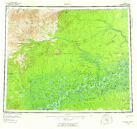 1956 Beaver1959 Print · USGSThe Yukon Flats and the Arctic Circle define this mid-century interior Alaska landscape. Researchers can trace the river's complex sloughs near Beaver and Stevens Village, or locate the historic Dall City site.7 unique versions available
End of results
Showing maps 1-3 of 3
Frequently asked questions
- What are the different types of historical maps available for Stevens Village?
- What is the oldest map of Stevens Village?
- Where can I purchase historical maps of Stevens Village for my home or office?
- Where can I download high-res historical maps of Stevens Village?
- Are there historical topographic maps available for Stevens Village?
- Is there historical aerial imagery available for Stevens Village?
- Where are historical maps of Stevens Village sourced from?