
1956 Map of Beaver A-5
USGS Topo · Published 1959About this map
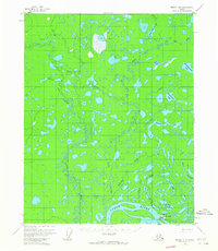
Stevens Village sits along the northern bank of the Yukon River, serving as a focal point for activity in this subarctic riverine landscape. The 1950s layout includes a localized Airstrip, a Cem, and a Cabin, indicating a community oriented around the river for transport and sustenance. To the north and west, the terrain is defined by a dense network of meandering waterways and countless lakes, including Little Dahl River and Datkokan River.
Find a feature on this map
21 named features on this map. Tap any name to fly to it.
Don’t see what you’re looking for? This feature index may not catch every label — zoom into the map to look around manually.
Map Details
Editions of this 1956 Beaver A-5 Map
2 editions found
Other maps of this area

1945 · Livengood
USGS Topo · 1:250,000

1951 · Livengood
USGS Topo · 1:250,000

1951 · Beaver
USGS Topo · 1:250,000

1952 · Livengood D-5
USGS Topo · 1:63,360

1953 · Livengood D-4
USGS Topo · 1:63,360

1954 · Livengood D-4
USGS Topo · 1:63,360

1956 · Beaver B-5
USGS Topo · 1:63,360

1956 · Beaver
USGS Topo · 1:250,000

1956 · Beaver A-4
USGS Topo · 1:63,360

1956 · Beaver B-4
USGS Topo · 1:63,360