
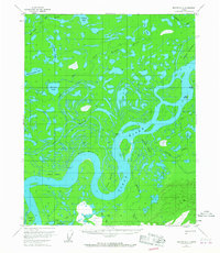
1956 Map of Beaver A-4
USGS Topo · Published 1959About this map
The Yukon River meanders through this interior Alaskan landscape, creating a complex network of braids, islands, and sloughs as it flowed in the mid-1950s. The river's dynamic path is evidenced by features like Windy Bend and several large landmasses within the channel, including Adams Island and Moose Island. Away from the main current, the terrain is dominated by an intricate system of wetlands and namesake sloughs such as Gamble Slough and Mail Slough, which hint at historical transport routes through the marshes.
Find a feature on this map
30 named features on this map. Tap any name to fly to it.
Don’t see what you’re looking for? This feature index may not catch every label — zoom into the map to look around manually.
Map Details
Editions of this 1956 Beaver A-4 Map
2 editions found
Other maps of this area

1945 · Livengood
USGS Topo · 1:250,000

1951 · Livengood
USGS Topo · 1:250,000

1951 · Beaver
USGS Topo · 1:250,000

1951 · Livengood D-3
USGS Topo · 1:63,360

1952 · Livengood D-5
USGS Topo · 1:63,360

1953 · Livengood D-4
USGS Topo · 1:63,360

1954 · Livengood D-4
USGS Topo · 1:63,360
1954 · Livengood D-3
USGS Topo · 1:63,360

1956 · Beaver A-5
USGS Topo · 1:63,360

1956 · Beaver B-3
USGS Topo · 1:63,360