Old Maps of Strelna, Alaska for Genealogy
Trace your family roots with 7 historic maps of Strelna. These high-res maps reveal old neighborhoods, homesites, landmarks, and streets — helping you uncover where your ancestors lived and how the area evolved over time.
- Explore historic neighborhoods: Identify where your relatives may have lived in the 1800s or 1900s.
- Compare maps over time: Trace the changes in streets, buildings, and landmarks for multi-generational research.
- Perfect for genealogy & ancestry research: Used by family historians and researchers to map out lineage and migration.
These maps are an incredible resource for exploring your personal connection to Strelna's past.
Strelna, AK maps
(7)- 1951 Map of Valdez C-1, 1964 Print
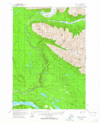 1951 Valdez C-11964 Print · USGSThe Copper River interior is captured here in the early fifties, centering on the settlement of Strelna. Researchers can trace the Old Railroad Grade and locate remote cabins or a high-altitude Mine near Elliott Creek.4 unique versions available
 - 1952 Map of Valdez
 1952 Valdez1952 Print · USGSCoastal Alaska met the interior via mountain passes and river valleys during the mid-century, before the 1964 earthquake altered the shoreline. Trace mining history at Midas Camp and Cliff Mine, or locate remote stations like Tiekel Cache and Copper Center.4 unique versions available
 - 1953 Map of Valdez C-1, 1954 Print
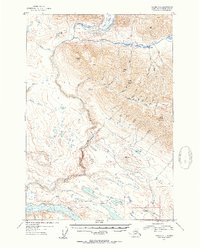 1953 Valdez C-11954 Print · USGSThe copper-rich mountains and river valleys of the Wrangell range come into focus during the early 1950s. Trace the path of industrial heritage along the Old Railroad Grade near Strelna or locate the remote Mine tucked beneath Alice Peak.2 unique versions available
 - 1960 Map of Valdez, 1967 Print
 1960 Valdez1967 Print · USGSCoastal and interior Alaska meet in this mid-century study of the Chugach Mountains and the copper-rich river valleys. Trace the legacy of early industry along the Copper River and Northwestern Railroad and locate settlements like Copper Center, Chitina, and Fort Liscum.6 unique versions available
 - 2016 Map of Valdez C-1 SE, 2016 Print
 2016 Valdez C-1 SE2016 Print · USGSCovers Strelna, including Unorganized Borough, United States, and other nearby areas
 - 2019 Map of Valdez C-1 SE, 2019 Print
 2019 Valdez C-1 SE2019 Print · USGSCovers Strelna, including Unorganized Borough, United States, and other nearby areas
 - 2023 Map of Valdez C-1 SE, 2023 Print
 2023 Valdez C-1 SE2023 Print · USGSThe Copper River region in the early twenty-first century remains a landscape of remote settlements and rugged trails. Genealogists and historians can trace the paths between Chitina and Strelna, or follow the Kotsina River Trl into the Wrangell Mountains.
End of results
Showing maps 1-7 of 7
Frequently asked questions
- What are the different types of historical maps available for Strelna?
- What is the oldest map of Strelna?
- Where can I purchase historical maps of Strelna for my home or office?
- Where can I download high-res historical maps of Strelna?
- Are there historical topographic maps available for Strelna?
- Is there historical aerial imagery available for Strelna?
- Where are historical maps of Strelna sourced from?