Old Maps of Sunnyside, Alaska for Genealogy
Trace your family roots with 7 historic maps of Sunnyside. These high-res maps reveal old neighborhoods, homesites, landmarks, and streets — helping you uncover where your ancestors lived and how the area evolved over time.
- Explore historic neighborhoods: Identify where your relatives may have lived in the 1800s or 1900s.
- Compare maps over time: Trace the changes in streets, buildings, and landmarks for multi-generational research.
- Perfect for genealogy & ancestry research: Used by family historians and researchers to map out lineage and migration.
These maps are an incredible resource for exploring your personal connection to Sunnyside's past.
Sunnyside, AK maps
(7)- 1951 Map of Sitka D-7, 1953 Print
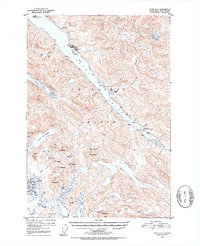 1951 Sitka D-71953 Print · USGSChichagof Island in the early fifties shows a landscape of remote mines, logging outposts, and new coastal settlements. Trace the early boundaries of Pelican or locate the historic Apex Mine and El Nido Mine nestled above Lisianski Inlet.6 unique versions available
 - 1951 Map of Sitka, 1958 Print
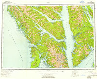 1951 Sitka1958 Print · USGSSoutheast Alaska in the early fifties reveals a landscape defined by water and remote coastal outposts. Genealogists and historians can trace established settlements like Sitka and Angoon alongside industrial markers like a Logging Camp and the Old Sitka ruins.6 unique versions available
 - 1952 Map of Sitka, 1953 Print
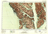 1952 Sitka1953 Print · USGSSoutheast Alaska in the early fifties is mapped here across the islands and straits of the Alexander Archipelago. Researchers can locate coastal outposts like Angoon and Tenakee, or trace the rugged shores of Sitka Sound to the slopes of Mt Edgecumbe.4 unique versions available
 - 1964 Map of Sitka
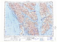 1964 Sitka1964 Print · USGSSoutheast Alaska's rugged archipelago is captured in the mid-twentieth century as maritime commerce and coastal outposts shaped the region. Genealogists and historians can trace established settlements like Sitka and Angoon or vanished points such as Gypsum and Manleyville.
 - 1997 Map of Sitka D-7, 2000 Print
 1997 Sitka D-72000 Print · USGSChichagof Island in the late nineties is a landscape of maritime commerce and deep-forest mining. Genealogists and historians can trace the foundations of Pelican, locate the Apex Mine and El Nido Mine, and follow the remote White Sulpher Springs Trail.
 - 2017 Map of Sitka D-7 NW, 2017 Print
 2017 Sitka D-7 NW2017 Print · USGSCovers Sunnyside, including Pelican, Unorganized Borough, and other nearby areas
 - 2021 Map of Sitka D-7 NW, 2021 Print
 2021 Sitka D-7 NW2021 Print · USGSThe northern reaches of Chichagof Island are shown here in the early twenty-first century, centered on the fishing community of Pelican. Researchers can trace the waterfront around Pelican Harbor or follow the Stag River Trl into the forest.
End of results
Showing maps 1-7 of 7
Top cities near Sunnyside
Frequently asked questions
- What are the different types of historical maps available for Sunnyside?
- What is the oldest map of Sunnyside?
- Where can I purchase historical maps of Sunnyside for my home or office?
- Where can I download high-res historical maps of Sunnyside?
- Are there historical topographic maps available for Sunnyside?
- Is there historical aerial imagery available for Sunnyside?
- Where are historical maps of Sunnyside sourced from?