Old Maps of Tanana, Alaska for Metal Detecting
Plan your next treasure hunt with 9 historic maps of Tanana. Find old homesites, ghost towns, trails, and gathering spots that may be lost to time — perfect for identifying promising metal detecting locations.
- Locate forgotten sites: Uncover places like long-lost settlements, abandoned rail lines, or gathering spots.
- Plan better hunts: Use map overlays combined with LiDAR or satellite views to narrow in on historically rich areas.
- Made for detectorists: Thousands of hobbyists use these maps to discover relics, coins, and hidden history.
Use these historic maps to boost your research and find new opportunities beneath the surface of Tanana.
Tanana, AK maps
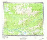
(9)- 1951 Map of Tanana, 1952 Print
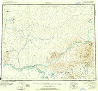 1951 Tanana1952 Print · USGSThe confluence of the Yukon and Tanana rivers serves as the hub for this early 1950s interior Alaska record. Genealogists and historians can trace riverside settlements like Tanana and Rampart, as well as mining outposts at Tofty and Eureka.3 unique versions available
 - 1952 Map of Tanana A-4, 1956 Print
 1952 Tanana A-41956 Print · USGSThe Yukon and Tanana rivers converge in this early 1950s survey, showing the complex riverine landscape before modern development. Researchers can locate the Indian Village near Mission Hill and trace remote routes like the Tractor Trails to Squaw Crossing.3 unique versions available
 - 1952 Map of Tanana A-5, 1957 Print
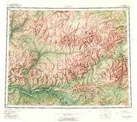
 1952 Tanana A-51957 Print · USGSAlaska's interior river country in the mid-fifties is captured here as the settlement of Tanana emerges as a key crossroads. Researchers can trace the era's vital transport links from a Sled Trail to the Tanana Airport and the local Cem.
 - 1953 Map of Tanana A-5, 1967 Print
 1953 Tanana A-51967 Print · USGSThe Yukon and Tozitna rivers meet here during the early fifties, centering on the vital river community of Tanana. Genealogists and historians can trace local landmarks like Mission Hill, the Cem, and the vital Sled Trail network through the subarctic brush.2 unique versions available
 - 1956 Map of Tanana, 1962 Print
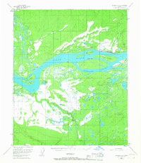
 1956 Tanana1962 Print · USGSInterior Alaska in the mid-fifties centers on the vital junction of the Yukon River and Tanana River. Researchers can trace the layout of Tanana and Rampart, locate the Placer Mine near Eureka, and follow the remote Winter Trail.4 unique versions available
 - 1960 Map of Tanana, 1978 Print
 1960 Tanana1978 Print · USGSThe Yukon and Tanana river systems converge in the mid-twentieth century, revealing a landscape of remote settlements and rugged mining districts. Researchers can trace the Tanana Allakaket Winter Trail and locate family sites at Manley Hot Springs or the Native Cem.4 unique versions available
 - 2016 Map of Tanana A-4 NW, 2016 Print
 2016 Tanana A-4 NW2016 Print · USGSCovers Tanana, including Unorganized Borough, United States, and other nearby areas
 - 2016 Map of Tanana A-5 NE, 2016 Print
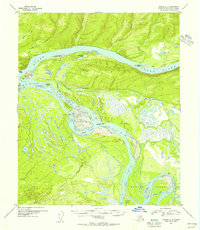
 2016 Tanana A-5 NE2016 Print · USGSThe riverfront settlement of Tanana stands at a vital Alaskan crossroads where the Yukon River shapes the geography. Researchers can trace local infrastructure from the Ralph M Calhoun Memorial Airport to the heights of Mission Hill and the complex channels of Corbusier Slough.
 - 2023 Map of Tanana A-4 NW, 2023 Print
 2023 Tanana A-4 NW2023 Print · USGSNear the convergence of the Yukon and Tanana Rivers in the early 2020s, this area reflects the unique geography of interior Alaska. Researchers can trace the local infrastructure of Tanana and locate landmarks like Tanana Cem, Mission Hill, and the White Alice Road.
End of results
Showing maps 1-9 of 9
Frequently asked questions
- What are the different types of historical maps available for Tanana?
- What is the oldest map of Tanana?
- Where can I purchase historical maps of Tanana for my home or office?
- Where can I download high-res historical maps of Tanana?
- Are there historical topographic maps available for Tanana?
- Is there historical aerial imagery available for Tanana?
- Where are historical maps of Tanana sourced from?