Old Maps of Taylor, Alaska
Explore 5 old maps of Taylor, spanning from 1950 to today. These high-resolution historic maps reveal how streets, neighborhoods, landmarks, and natural features evolved over time — perfect for genealogy, metal detecting, research, and local history exploration.
What you can do with these maps:
- See how Taylor changed over time: Compare historical maps to modern-day views to trace roads, homesites, rail lines & more.
- View detailed metadata: Each map includes creators, publishers, year, scale, and archive source.
- Overlay maps with satellite & LiDAR: Visualize the past alongside modern tools to explore terrain & human change.
- Trusted historical sources: Maps sourced from the USGS, Library of Congress, and other archives.
- Access maps your way: View online, download high-res files, or order prints for personal or research use.
Start exploring old maps of Taylor to uncover forgotten places, hidden landmarks, and the deep history beneath your feet.
Taylor, AK maps
(5)- 1950 Map of Bendeleben C-6, 1955 Print
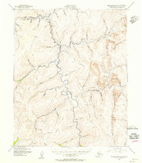 1950 Bendeleben C-61955 Print · USGSMining operations and aviation outposts defined the Kougarok River region in the early fifties. Researchers can trace the rugged network of tractor trails connecting Taylor and a remote Gold Mine to strategic sites like the Harris Dome Landing Strip.2 unique versions available
 - 1950 Map of Bendeleben, 1956 Print
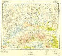 1950 Bendeleben1956 Print · USGSThe Seward Peninsula in the early fifties shows a rugged interior reliant on aviation and gold mining. Researchers can trace remote outposts like Bunker Hill Station and Aurora or find landing strips at Utica Landing Area.6 unique versions available
 - 1951 Map of Bendeleben
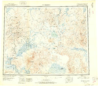 1951 Bendeleben1951 Print · USGSThe central Seward Peninsula in the early fifties was a rugged frontier of isolated mining outposts and volcanic fields. Researchers can trace the path of the Railroad (Abandoned) and locate early settlements like Noxapaga, Aurora, and Shelton.2 unique versions available
 - 1964 Map of Bendeleben
 1964 Bendeleben1964 Print · USGSThe central Seward Peninsula comes into focus in the 1950s, showing a landscape of volcanic cones, river systems, and mining outposts. Trace the history of remote settlements like Taylor and Dahl or locate seasonal cabins near Imuruk Lake and Death Valley.
 - 2014 Map of Bendeleben C-6 NW, 2014 Print
 2014 Bendeleben C-6 NW2014 Print · USGSThe remote interior of Alaska's Seward Peninsula is captured here in the early twenty-first century, centered on the historic settlement of Taylor. Researchers can trace the drainages of the Kougarok River and fly-in access points like Taylor Airport along with gold-rush era names like Homestake Cr and Eldorado Cr.
End of results
Showing maps 1-5 of 5
Frequently asked questions
- What are the different types of historical maps available for Taylor?
- What is the oldest map of Taylor?
- Where can I purchase historical maps of Taylor for my home or office?
- Where can I download high-res historical maps of Taylor?
- Are there historical topographic maps available for Taylor?
- Is there historical aerial imagery available for Taylor?
- Where are historical maps of Taylor sourced from?