1900s (20th Century) Maps of Taylor, Alaska
Explore 4 historic maps of Taylor from the 1900s (20th Century). These maps offer a rare glimpse into what life looked like during the 1900s — showing old roads, neighborhoods, homes, and landmarks that have changed or disappeared over time.
Whether you're researching your family's past, planning a metal detecting trip, or studying how Taylor's landscape evolved across the 1900s, these high-resolution maps are a powerful tool for exploring the history of this region.
- Focus on a specific era: All maps on this page are from the 1900s, giving you a focused view of this time period.
- See what’s changed: Compare century-old streets, trails, and buildings to today's modern landscape using overlays and satellite layers.
- Research with precision: Use these maps for genealogy, historical research, land use analysis, or educational projects.
- View, download, or print: Maps are fully viewable online in high resolution, and can be downloaded or printed for your own records.
Start exploring Taylor's history through authentic maps from the 1900s. This is your window into the past.
Taylor, AK maps
(4)- 1950 Map of Bendeleben C-6, 1955 Print
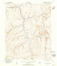 1950 Bendeleben C-61955 Print · USGSMining operations and aviation outposts defined the Kougarok River region in the early fifties. Researchers can trace the rugged network of tractor trails connecting Taylor and a remote Gold Mine to strategic sites like the Harris Dome Landing Strip.2 unique versions available
 - 1950 Map of Bendeleben, 1956 Print
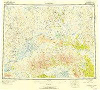 1950 Bendeleben1956 Print · USGSThe Seward Peninsula in the early fifties shows a rugged interior reliant on aviation and gold mining. Researchers can trace remote outposts like Bunker Hill Station and Aurora or find landing strips at Utica Landing Area.6 unique versions available
 - 1951 Map of Bendeleben
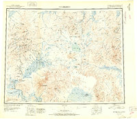 1951 Bendeleben1951 Print · USGSThe central Seward Peninsula in the early fifties was a rugged frontier of isolated mining outposts and volcanic fields. Researchers can trace the path of the Railroad (Abandoned) and locate early settlements like Noxapaga, Aurora, and Shelton.2 unique versions available
 - 1964 Map of Bendeleben
 1964 Bendeleben1964 Print · USGSThe central Seward Peninsula comes into focus in the 1950s, showing a landscape of volcanic cones, river systems, and mining outposts. Trace the history of remote settlements like Taylor and Dahl or locate seasonal cabins near Imuruk Lake and Death Valley.
End of results
Showing maps 1-4 of 4
Frequently asked questions
- What are the different types of historical maps available for Taylor?
- What is the oldest map of Taylor?
- Where can I purchase historical maps of Taylor for my home or office?
- Where can I download high-res historical maps of Taylor?
- Are there historical topographic maps available for Taylor?
- Is there historical aerial imagery available for Taylor?
- Where are historical maps of Taylor sourced from?