
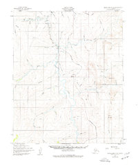
1950 Map of Bendeleben C-6
USGS Topo · Published 1955About this map
The Kougarok River serves as the central artery for this remote Seward Peninsula mining landscape, where early 1950s infrastructure supports gold exploration. The settlement of Taylor appears as a key hub along the river, connected to the surrounding drainage systems by a network of tractor trails. Evidence of industry is scattered throughout the region, most notably at the Gold Mine near the headwaters of Washington Creek. Logistics for these interior operations relied heavily on aviation, as seen by the presence of a Landing Strip near Taylor and the high-altitude Harris Dome Landing Strip positioned near Harris Dome. The map illustrates a transitional period for transportation, featuring several routes marked as Under Construction or designated as Winter Trails, snaking through the drainages of California Creek and Eureka Creek.
Find a feature on this map
55 named features on this map. Tap any name to fly to it.
Don’t see what you’re looking for? This feature index may not catch every label — zoom into the map to look around manually.
Map Details
Editions of this 1950 Bendeleben C-6 Map
2 editions found
Other maps of this area

1950 · Bendeleben C-5
USGS Topo · 1:63,360

1950 · Bendeleben B-5
USGS Topo · 1:63,360

1950 · Bendeleben B-6
USGS Topo · 1:63,360

1950 · Bendeleben D-6
USGS Topo · 1:63,360

1950 · Teller
USGS Topo · 1:250,000

1950 · Bendeleben D-5
USGS Topo · 1:63,360

1950 · Bendeleben
USGS Topo · 1:250,000

1950 · Teller B-1
USGS Topo · 1:63,360

1950 · Teller D-1
USGS Topo · 1:63,360
1950 · Teller C-1
USGS Topo · 1:63,360