1900s (20th Century) Maps of Tofty, Alaska
Explore 5 historic maps of Tofty from the 1900s (20th Century). These maps offer a rare glimpse into what life looked like during the 1900s — showing old roads, neighborhoods, homes, and landmarks that have changed or disappeared over time.
Whether you're researching your family's past, planning a metal detecting trip, or studying how Tofty's landscape evolved across the 1900s, these high-resolution maps are a powerful tool for exploring the history of this region.
- Focus on a specific era: All maps on this page are from the 1900s, giving you a focused view of this time period.
- See what’s changed: Compare century-old streets, trails, and buildings to today's modern landscape using overlays and satellite layers.
- Research with precision: Use these maps for genealogy, historical research, land use analysis, or educational projects.
- View, download, or print: Maps are fully viewable online in high resolution, and can be downloaded or printed for your own records.
Start exploring Tofty's history through authentic maps from the 1900s. This is your window into the past.
Tofty, AK maps
(5)- 1951 Map of Tanana, 1952 Print
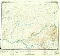 1951 Tanana1952 Print · USGSThe confluence of the Yukon and Tanana rivers serves as the hub for this early 1950s interior Alaska record. Genealogists and historians can trace riverside settlements like Tanana and Rampart, as well as mining outposts at Tofty and Eureka.3 unique versions available
 - 1952 Map of Tanana A-2, 1956 Print
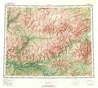
 1952 Tanana A-21956 Print · USGSThe Alaskan interior during the early fifties reveals a rugged frontier of gold mining and remote outposts. Researchers can trace the hydraulic mining Ditch lines and transport routes like the Sled Road connecting Manley Hot Springs to remote mountain Cabins.
 - 1953 Map of Tanana A-2, 1965 Print
 1953 Tanana A-21965 Print · USGSThe interior Alaska wilderness near the Tanana River was a landscape of remote outposts and mining activity in the early fifties. Researchers can locate specific sites like the Cem at Tofty, the Manley Hot Springs settlement, and several Landing Strips.3 unique versions available
 - 1956 Map of Tanana, 1962 Print
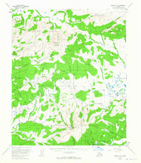
 1956 Tanana1962 Print · USGSInterior Alaska in the mid-fifties centers on the vital junction of the Yukon River and Tanana River. Researchers can trace the layout of Tanana and Rampart, locate the Placer Mine near Eureka, and follow the remote Winter Trail.4 unique versions available
 - 1960 Map of Tanana, 1978 Print
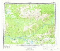 1960 Tanana1978 Print · USGSThe Yukon and Tanana river systems converge in the mid-twentieth century, revealing a landscape of remote settlements and rugged mining districts. Researchers can trace the Tanana Allakaket Winter Trail and locate family sites at Manley Hot Springs or the Native Cem.4 unique versions available
End of results
Showing maps 1-5 of 5
Frequently asked questions
- What are the different types of historical maps available for Tofty?
- What is the oldest map of Tofty?
- Where can I purchase historical maps of Tofty for my home or office?
- Where can I download high-res historical maps of Tofty?
- Are there historical topographic maps available for Tofty?
- Is there historical aerial imagery available for Tofty?
- Where are historical maps of Tofty sourced from?