Old Maps of Tofty, Alaska for Genealogy
Trace your family roots with 6 historic maps of Tofty. These high-res maps reveal old neighborhoods, homesites, landmarks, and streets — helping you uncover where your ancestors lived and how the area evolved over time.
- Explore historic neighborhoods: Identify where your relatives may have lived in the 1800s or 1900s.
- Compare maps over time: Trace the changes in streets, buildings, and landmarks for multi-generational research.
- Perfect for genealogy & ancestry research: Used by family historians and researchers to map out lineage and migration.
These maps are an incredible resource for exploring your personal connection to Tofty's past.
Tofty, AK maps
(6)- 1951 Map of Tanana, 1952 Print
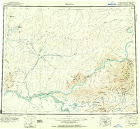 1951 Tanana1952 Print · USGSThe confluence of the Yukon and Tanana rivers serves as the hub for this early 1950s interior Alaska record. Genealogists and historians can trace riverside settlements like Tanana and Rampart, as well as mining outposts at Tofty and Eureka.3 unique versions available
 - 1952 Map of Tanana A-2, 1956 Print
 1952 Tanana A-21956 Print · USGSThe Alaskan interior during the early fifties reveals a rugged frontier of gold mining and remote outposts. Researchers can trace the hydraulic mining Ditch lines and transport routes like the Sled Road connecting Manley Hot Springs to remote mountain Cabins.
 - 1953 Map of Tanana A-2, 1965 Print
 1953 Tanana A-21965 Print · USGSThe interior Alaska wilderness near the Tanana River was a landscape of remote outposts and mining activity in the early fifties. Researchers can locate specific sites like the Cem at Tofty, the Manley Hot Springs settlement, and several Landing Strips.3 unique versions available
 - 1956 Map of Tanana, 1962 Print
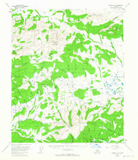
 1956 Tanana1962 Print · USGSInterior Alaska in the mid-fifties centers on the vital junction of the Yukon River and Tanana River. Researchers can trace the layout of Tanana and Rampart, locate the Placer Mine near Eureka, and follow the remote Winter Trail.4 unique versions available
 - 1960 Map of Tanana, 1978 Print
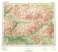
 1960 Tanana1978 Print · USGSThe Yukon and Tanana river systems converge in the mid-twentieth century, revealing a landscape of remote settlements and rugged mining districts. Researchers can trace the Tanana Allakaket Winter Trail and locate family sites at Manley Hot Springs or the Native Cem.4 unique versions available
 - 2017 Map of Tanana A-2 SW, 2017 Print
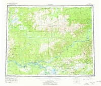
 2017 Tanana A-2 SW2017 Print · USGSThe mining settlement of Tofty and its surrounding gold-bearing gulches are documented here in the early twenty-first century. Researchers can trace the path of Tofty Road and locate family-named landmarks like Miller Gulch, Dalton Gulch, and Bean Ridge.
End of results
Showing maps 1-6 of 6
Frequently asked questions
- What are the different types of historical maps available for Tofty?
- What is the oldest map of Tofty?
- Where can I purchase historical maps of Tofty for my home or office?
- Where can I download high-res historical maps of Tofty?
- Are there historical topographic maps available for Tofty?
- Is there historical aerial imagery available for Tofty?
- Where are historical maps of Tofty sourced from?