Old Maps of Umkumiut, Toksook Bay for Hiking & Exploration
Hike through history with 6 historic maps of Umkumiut. Explore old trails, ghost towns, and forgotten backroads — perfect for outdoor adventurers and local explorers.
- Rediscover forgotten places: Map out old mining camps, roads, and footpaths that no longer exist on modern maps.
- Layer with modern tools: Combine with LiDAR or satellite views to plan hikes through historical terrain.
- Made for exploration: Popular among hikers, overlanders, and local history lovers.
Use these maps to find adventure and explore the hidden past of Umkumiut.
Umkumiut, Toksook Bay maps
(6)- 1951 Map of Nunivak Island
 1951 Nunivak Island1951 Print · USGSNunivak Island and the eastern Bering Sea coast appear here in the early fifties, showing a remote landscape of subsistence settlements and wildlife refuge lands. Researchers can trace historic sites like Mekoryuk, Kigoumiut, and the Nash Harbor Landing Area.
 - 1954 Map of Nunivak Island, 1961 Print
 1954 Nunivak Island1961 Print · USGSNunivak Island and the adjacent Etolin Strait are documented in the mid-1950s, showing a traditional landscape of coastal camps and settlements. Researchers can locate established sites like Mekoryuk and Tanunak or trace seasonal camps at Nash Harbor and Kuvloniut.4 unique versions available
 - 1954 Map of Nunivak Island B-1, 1971 Print
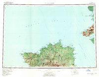
 1954 Nunivak Island B-11971 Print · USGSNelson Island and the surrounding Bering Sea waters are captured here in the mid-fifties, showing the coastal geography of western Alaska. Researchers can locate the settlement of Umkumiut and trace the shoreline between Chinigyak Cape and Atrnak Point.
 - 1958 Map of Nunivak Island
 1958 Nunivak Island1958 Print · USGSNunivak Island and Nelson Island appear in the mid-1950s as a series of remote coastal outposts and wildlife habitats. Researchers can locate seasonal camps and landing sites like Nash Harbor, the settlement of Mekoryuk, and landmarks like Cape Mohican.
 - 1964 Map of Nunivak Island
 1964 Nunivak Island1964 Print · USGSNunivak Island and the Bering Sea coast appear here during the mid-1960s, documenting a landscape of traditional Indigenous settlements and federal wildlife refuges. Researchers can locate seasonal camp sites like Luktukukwik and major landmarks including Mekoryuk and the Cape Mohican Light.
 - 2020 Map of Nunivak Island B-1 NW, 2020 Print
 2020 Nunivak Island B-1 NW2020 Print · USGSNunivak Island's northern coastline is captured in the early twenty-first century, showing the remote waters of the Etolin Strait. Researchers can locate the settlement of Umkumiute and the coastal rise at Atrnak Point along the edge of the Bering Sea.
End of results
Showing maps 1-6 of 6
Top cities near Umkumiut
Frequently asked questions
- What are the different types of historical maps available for Umkumiut?
- What is the oldest map of Umkumiut?
- Where can I purchase historical maps of Umkumiut for my home or office?
- Where can I download high-res historical maps of Umkumiut?
- Are there historical topographic maps available for Umkumiut?
- Is there historical aerial imagery available for Umkumiut?
- Where are historical maps of Umkumiut sourced from?