Old Maps of Unalakleet, Alaska
Explore 6 old maps of Unalakleet, spanning from 1950 to today. These high-resolution historic maps reveal how streets, neighborhoods, landmarks, and natural features evolved over time — perfect for genealogy, metal detecting, research, and local history exploration.
What you can do with these maps:
- See how Unalakleet changed over time: Compare historical maps to modern-day views to trace roads, homesites, rail lines & more.
- View detailed metadata: Each map includes creators, publishers, year, scale, and archive source.
- Overlay maps with satellite & LiDAR: Visualize the past alongside modern tools to explore terrain & human change.
- Trusted historical sources: Maps sourced from the USGS, Library of Congress, and other archives.
- Access maps your way: View online, download high-res files, or order prints for personal or research use.
Start exploring old maps of Unalakleet to uncover forgotten places, hidden landmarks, and the deep history beneath your feet.
Unalakleet, AK maps
(6)- 1950 Map of Unalakleet D-4, 1958 Print
 1950 Unalakleet D-41958 Print · USGSIn the early 1950s, the coastal village of Unalakleet stood as a vital subarctic crossroads where the river met the sea. Researchers can trace the layout of the Unalakleet Native Reservation, early aviation at the Airstrip, and remote outposts like Blueberry Pt.2 unique versions available
 - 1951 Map of Unalakleet
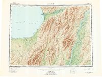
 1951 Unalakleet1951 Print · USGSWestern Alaska's coastal and river corridors are captured in the early 1950s, showing the vital connection between Norton Sound and the interior. Researchers can trace the Winter Trail networks and locate remote outposts like Golsovia and the Coal Mine near Unalakleet.
 - 1952 Map of Unalakleet, 1960 Print
 1952 Unalakleet1960 Print · USGSWestern Alaska in the early fifties shows a landscape of coastal settlements and interior river networks. Researchers can trace the Winter Trail and locate sites like the Williams Mine or the village of Unalakleet at the edge of the sound.8 unique versions available
 - 1964 Map of Unalakleet
 1964 Unalakleet1964 Print · USGSThe northern shores of Norton Sound and the interior Yukon River valley are documented here in the early sixties. Genealogists and researchers can trace remote outposts like Unalakleet, Golsovia, and the Williams Mine.
 - 2016 Map of Unalakleet D-4 NW, 2016 Print
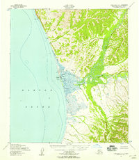
 2016 Unalakleet D-4 NW2016 Print · USGSCoastal Nome Census Area comes into focus during the mid-2010s, where the waters of Norton Sound meet the Seward Peninsula. Researchers can trace the layout of Unalakleet, from the Unalakleet Airport to local landmarks like Blueberry Point and Kouwegok Slough.
 - 2016 Map of Unalakleet D-4 SW, 2016 Print
 2016 Unalakleet D-4 SW2016 Print · USGSThe coastal settlement of Unalakleet is shown at the edge of Norton Sound in 2016, where the river meets the sea. Genealogists and researchers can trace the town layout along Main Street and explore coastal features like Cramberry Slough and the Costal Route to Tolstoi Point.
End of results
Showing maps 1-6 of 6
Frequently asked questions
- What are the different types of historical maps available for Unalakleet?
- What is the oldest map of Unalakleet?
- Where can I purchase historical maps of Unalakleet for my home or office?
- Where can I download high-res historical maps of Unalakleet?
- Are there historical topographic maps available for Unalakleet?
- Is there historical aerial imagery available for Unalakleet?
- Where are historical maps of Unalakleet sourced from?