1900s (20th Century) Maps of Unalakleet, Alaska
Explore 4 historic maps of Unalakleet from the 1900s (20th Century). These maps offer a rare glimpse into what life looked like during the 1900s — showing old roads, neighborhoods, homes, and landmarks that have changed or disappeared over time.
Whether you're researching your family's past, planning a metal detecting trip, or studying how Unalakleet's landscape evolved across the 1900s, these high-resolution maps are a powerful tool for exploring the history of this region.
- Focus on a specific era: All maps on this page are from the 1900s, giving you a focused view of this time period.
- See what’s changed: Compare century-old streets, trails, and buildings to today's modern landscape using overlays and satellite layers.
- Research with precision: Use these maps for genealogy, historical research, land use analysis, or educational projects.
- View, download, or print: Maps are fully viewable online in high resolution, and can be downloaded or printed for your own records.
Start exploring Unalakleet's history through authentic maps from the 1900s. This is your window into the past.
Unalakleet, AK maps
(4)- 1950 Map of Unalakleet D-4, 1958 Print
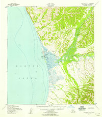 1950 Unalakleet D-41958 Print · USGSIn the early 1950s, the coastal village of Unalakleet stood as a vital subarctic crossroads where the river met the sea. Researchers can trace the layout of the Unalakleet Native Reservation, early aviation at the Airstrip, and remote outposts like Blueberry Pt.2 unique versions available
 - 1951 Map of Unalakleet
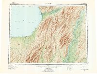
 1951 Unalakleet1951 Print · USGSWestern Alaska's coastal and river corridors are captured in the early 1950s, showing the vital connection between Norton Sound and the interior. Researchers can trace the Winter Trail networks and locate remote outposts like Golsovia and the Coal Mine near Unalakleet.
 - 1952 Map of Unalakleet, 1960 Print
 1952 Unalakleet1960 Print · USGSWestern Alaska in the early fifties shows a landscape of coastal settlements and interior river networks. Researchers can trace the Winter Trail and locate sites like the Williams Mine or the village of Unalakleet at the edge of the sound.8 unique versions available
 - 1964 Map of Unalakleet
 1964 Unalakleet1964 Print · USGSThe northern shores of Norton Sound and the interior Yukon River valley are documented here in the early sixties. Genealogists and researchers can trace remote outposts like Unalakleet, Golsovia, and the Williams Mine.
End of results
Showing maps 1-4 of 4
Frequently asked questions
- What are the different types of historical maps available for Unalakleet?
- What is the oldest map of Unalakleet?
- Where can I purchase historical maps of Unalakleet for my home or office?
- Where can I download high-res historical maps of Unalakleet?
- Are there historical topographic maps available for Unalakleet?
- Is there historical aerial imagery available for Unalakleet?
- Where are historical maps of Unalakleet sourced from?