Old Maps of Dutch Harbor, Unalaska for Academic Research
Study the evolution of Dutch Harbor with 3 high-resolution historic maps. Whether you're teaching, researching, or modeling changes in land use, these maps provide essential visual documentation of urban, environmental, and geographic change.
- Analyze long-term change: Track patterns in development, transportation, and natural features.
- Ideal for environmental or urban studies: Support academic projects with primary historical map data.
- Use in the classroom or lab: Educators and researchers rely on these maps to bring historical context to life.
These maps are a powerful tool for teaching, research, and visualizing how Dutch Harbor has changed over the decades.
Dutch Harbor, Unalaska maps
(3)- 1951 Map of Unalaska, 1952 Print
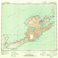 1951 Unalaska1952 Print · USGSThe Fox Islands are shown during the strategic post-war period when military installations still guarded the Aleutian chain. Genealogists and historians can trace the locations of Makushin and Kashega alongside the footprints of Fort Mears and Fort Glenn.10 unique versions available
 - 1990 Map of Unalaska C-2
 1990 Unalaska C-21990 Print · USGSThe maritime hubs of Unalaska and Dutch Harbor are shown in detail during the late twentieth century, highlighting the area's essential shipping and aviation infrastructure. Researchers can trace local landmarks like City Hall, the Cem, and harbor features from Spithead to Amaknak Island.2 unique versions available
 - 2021 Map of Unalaska C-2 NW, 2021 Print
 2021 Unalaska C-2 NW2021 Print · USGSThe Aleutian landscape of Unalaska and Dutch Harbor comes into focus in this recent survey of the Bering Sea coast. Trace maritime and aviation history from Amaknak Island to landmarks like the Holy Ascension Cathedral Church Cem and Unalaska Airport.
End of results
Showing maps 1-3 of 3
Top cities near Dutch Harbor
Frequently asked questions
- What are the different types of historical maps available for Dutch Harbor?
- What is the oldest map of Dutch Harbor?
- Where can I purchase historical maps of Dutch Harbor for my home or office?
- Where can I download high-res historical maps of Dutch Harbor?
- Are there historical topographic maps available for Dutch Harbor?
- Is there historical aerial imagery available for Dutch Harbor?
- Where are historical maps of Dutch Harbor sourced from?