1900s (20th Century) Maps of Whittier, Alaska
Explore 8 historic maps of Whittier from the 1900s (20th Century). These maps offer a rare glimpse into what life looked like during the 1900s — showing old roads, neighborhoods, homes, and landmarks that have changed or disappeared over time.
Whether you're researching your family's past, planning a metal detecting trip, or studying how Whittier's landscape evolved across the 1900s, these high-resolution maps are a powerful tool for exploring the history of this region.
- Focus on a specific era: All maps on this page are from the 1900s, giving you a focused view of this time period.
- See what’s changed: Compare century-old streets, trails, and buildings to today's modern landscape using overlays and satellite layers.
- Research with precision: Use these maps for genealogy, historical research, land use analysis, or educational projects.
- View, download, or print: Maps are fully viewable online in high resolution, and can be downloaded or printed for your own records.
Start exploring Whittier's history through authentic maps from the 1900s. This is your window into the past.
Whittier, AK maps
(8)- 1951 Map of Seward
 1951 Seward1951 Print · USGSThe Kenai Peninsula and Prince William Sound come to life in the early 1950s as the rail and maritime networks linked remote coastal outposts. Genealogists and historians can trace the Alaska Railroad corridor through Seward, find the Jesse Lee Indian School, and locate isolated camps like Latouche and Chenega.4 unique versions available
 - 1951 Map of Seward D-5, 1963 Print
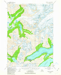 1951 Seward D-51963 Print · USGSWhittier serves as a critical railroad terminus and maritime gateway in the early fifties. Local researchers can trace the industrial layout of the town, including The Tunnel, the CAA Station, and the proximity of the Portage Mine.3 unique versions available
 - 1952 Map of Seward D-5, 1954 Print
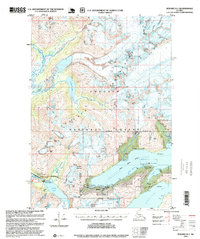
 1952 Seward D-51954 Print · USGSThe strategic port of Whittier and its surrounding glacial peaks are captured here in the early fifties during its peak era as a military rail terminal. Researchers can trace the vital Alaska Railroad Tunnel, the Airstrip, and the massive face of Portage Glacier.2 unique versions available
 - 1953 Map of Seward, 1956 Print
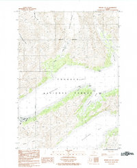
 1953 Seward1956 Print · USGSThe Kenai Peninsula and Prince William Sound are documented in the early 1950s as the rail and road networks expanded. Trace the route of the Alaska Railroad and find early settlements like Seward, Moose Pass, and Latouche.12 unique versions available
 - 1959 Map of Seward
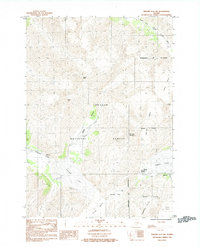
 1959 Seward1959 Print · USGSThe Kenai Peninsula and Prince William Sound are captured here during the mid-century, showing the vital transit corridor between Seward and the interior. Researchers can trace the Alaska Railroad through Whittier and locate historic coastal settlements like Chenega and Latouche.
 - 1984 Map of Seward D-5 SE
 1984 Seward D-5 SE1984 Print · USGSWhittier and the surrounding ice fields of the Prince William Sound are captured here in the mid-1980s. Researchers can trace the rugged coastline from the port at Passage Canal to the depths of Shotgun Cove and the massive Billings Glacier.
 - 1984 Map of Seward D-5 SW
 1984 Seward D-5 SW1984 Print · USGSThe rail-and-water gateway at Whittier is shown in the mid-1980s, revealing a landscape defined by massive ice and narrow coastal corridors. Researchers can trace the proximity of the town to Passage Canal and the dramatic reach of Portage Glacier.
 - 1995 Map of Seward D-5, 1999 Print
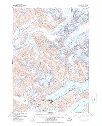
 1995 Seward D-51999 Print · USGSWhittier and the surrounding Chugach peaks are captured here in the mid-nineties, showing the strategic port and its rail connections. Researchers can trace the layout of the City of Whittier, the old Portage Mine, and the route of the Byron Glacier Trail.
End of results
Showing maps 1-8 of 8
Frequently asked questions
- What are the different types of historical maps available for Whittier?
- What is the oldest map of Whittier?
- Where can I purchase historical maps of Whittier for my home or office?
- Where can I download high-res historical maps of Whittier?
- Are there historical topographic maps available for Whittier?
- Is there historical aerial imagery available for Whittier?
- Where are historical maps of Whittier sourced from?