Old Maps of Wiseman, Alaska for Hiking & Exploration
Hike through history with 5 historic maps of Wiseman. Explore old trails, ghost towns, and forgotten backroads — perfect for outdoor adventurers and local explorers.
- Rediscover forgotten places: Map out old mining camps, roads, and footpaths that no longer exist on modern maps.
- Layer with modern tools: Combine with LiDAR or satellite views to plan hikes through historical terrain.
- Made for exploration: Popular among hikers, overlanders, and local history lovers.
Use these maps to find adventure and explore the hidden past of Wiseman.
Wiseman, AK maps
(5)- 1951 Map of Wiseman, 1952 Print
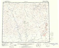 1951 Wiseman1952 Print · USGSThe Central Brooks Range in the early 1950s remained a frontier of isolated mining camps and river corridors. Researchers can trace the layout of Wiseman, Nolan, and Coldfoot, alongside remote landmarks like Pamichtuk Lake and the peaks of the Endicott Mountains.2 unique versions available
 - 1956 Map of Wiseman, 1959 Print
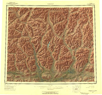 1956 Wiseman1959 Print · USGSThe central Brooks Range and the mining outposts of the Koyukuk valley are documented here in the mid-fifties. Researchers can locate remote cabins, placer mines, and historic landings like Wiseman, Coldfoot, and Tramway Bar along the Koyukuk River.10 unique versions available
 - 1964 Map of Wiseman
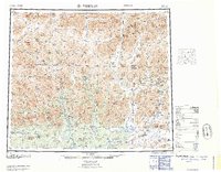 1964 Wiseman1964 Print · USGSThe Koyukuk River wilderness comes into focus in the mid-1950s, highlighting the isolated mining outposts of the Central Brooks Range. Researchers can trace the Tramway Bar Trail and locate historic Placer Mine sites near Wiseman, Nolan, and Coldfoot.
 - 1971 Map of Wiseman B-1, 1974 Print
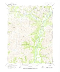 1971 Wiseman B-11974 Print · USGSThe northern interior near Wiseman is captured in the early seventies, a landscape still shaped by the gold rush and seasonal river travel. Researchers can trace the Winter Road and find remote sites like the Placer Mine at Nolan and the small Cem near the river.3 unique versions available
 - 2017 Map of Wiseman B-1 NE, 2017 Print
 2017 Wiseman B-1 NE2017 Print · USGSThe settlement of Wiseman is shown here in the 2010s, nestled between the Middle Fork Koyukuk River and high peaks. Researchers can trace the path of the Alaska Pipeline alongside local landmarks like Midnight Dome and Wiseman Airport.
End of results
Showing maps 1-5 of 5
Frequently asked questions
- What are the different types of historical maps available for Wiseman?
- What is the oldest map of Wiseman?
- Where can I purchase historical maps of Wiseman for my home or office?
- Where can I download high-res historical maps of Wiseman?
- Are there historical topographic maps available for Wiseman?
- Is there historical aerial imagery available for Wiseman?
- Where are historical maps of Wiseman sourced from?