Old Maps of Yistletaw, Alaska for Metal Detecting
Plan your next treasure hunt with 7 historic maps of Yistletaw. Find old homesites, ghost towns, trails, and gathering spots that may be lost to time — perfect for identifying promising metal detecting locations.
- Locate forgotten sites: Uncover places like long-lost settlements, abandoned rail lines, or gathering spots.
- Plan better hunts: Use map overlays combined with LiDAR or satellite views to narrow in on historically rich areas.
- Made for detectorists: Thousands of hobbyists use these maps to discover relics, coins, and hidden history.
Use these historic maps to boost your research and find new opportunities beneath the surface of Yistletaw.
Yistletaw, AK maps
(7)- 1945 Map of Nulato, 1954 Print
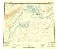 1945 Nulato1954 Print · USGSThe Yukon and Koyukuk rivers serve as the lifeblood of this Alaskan interior region during the mid-forties. Researchers can trace the traditional Kaltag Portage and locate established riverside settlements like Nulato, Galena, and the village at Koyukuk.2 unique versions available
 - 1951 Map of Nulato
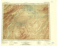 1951 Nulato1951 Print · USGSThe Yukon and Koyukuk Rivers meet in this mid-century Alaska survey, showing the vital river outposts and sloughs of the interior. Researchers can trace remote river life through landing areas at Galena, riverbank Cabins, and landmarks like Bishop Rock and Traders Island.2 unique versions available
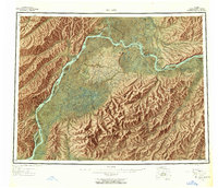
 - 1952 Map of Nulato D-3, 1957 Print
 1952 Nulato D-31957 Print · USGSThe Yukon River interior was a wilderness of shifting channels and early communication corridors in the early fifties. Historians can trace the path of the Abandoned Telegraph Line and locate river landmarks like Bishop Rock and Yistletaw.
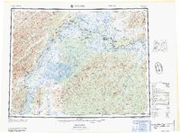
 - 1952 Map of Nulato, 1958 Print
 1952 Nulato1958 Print · USGSThe Yukon River interior comes into focus during the early fifties, documenting a region of river settlements and rising military aviation. Researchers can trace the Abandoned Telegraph Line, locate the Louden Cem, or study the footprint of the Galena Air Force Base.4 unique versions available
 - 1954 Map of Nulato D-3, 1967 Print
 1954 Nulato D-31967 Print · USGSThe Yukon River interior comes into focus during the mid-fifties, showing the vital waterways and early communication corridors of the Alaskan wilderness. Researchers can trace the Abandoned Telegraph Line and locate the settlement of Yistletaw near Bishop Rock.
 - 1964 Map of Nulato
 1964 Nulato1964 Print · USGSThe Yukon interior in the early sixties reveals a landscape shaped by river travel and Cold War aviation. Researchers can trace the ABANDONED TELEGRAPH LINE across the northern wilderness or locate historical sites like Nulato, Louden, and the Galena Air Force Base.
 - 2017 Map of Nulato D-3 SW, 2017 Print
 2017 Nulato D-3 SW2017 Print · USGSThe interior Alaskan wilderness along the Yukon River is captured here during the late twenty-tens. Map collectors can trace the river's path past Whontleya, Bishop Rock, and the remote settlement at Yistletaw.
End of results
Showing maps 1-7 of 7
Frequently asked questions
- What are the different types of historical maps available for Yistletaw?
- What is the oldest map of Yistletaw?
- Where can I purchase historical maps of Yistletaw for my home or office?
- Where can I download high-res historical maps of Yistletaw?
- Are there historical topographic maps available for Yistletaw?
- Is there historical aerial imagery available for Yistletaw?
- Where are historical maps of Yistletaw sourced from?