1990s Maps of Bowie, Arizona
Explore 2 historic maps of Bowie from the 1990s. These maps offer a rare glimpse into what life looked like during the 1990s — showing old roads, neighborhoods, homes, and landmarks that have changed or disappeared over time.
Whether you're researching your family's past, planning a metal detecting trip, or studying how Bowie's landscape evolved across the 1990s, these high-resolution maps are a powerful tool for exploring the history of this region.
- Focus on a specific era: All maps on this page are from the 1990s, giving you a focused view of this time period.
- See what’s changed: Compare century-old streets, trails, and buildings to today's modern landscape using overlays and satellite layers.
- Research with precision: Use these maps for genealogy, historical research, land use analysis, or educational projects.
- View, download, or print: Maps are fully viewable online in high resolution, and can be downloaded or printed for your own records.
Start exploring Bowie's history through authentic maps from the 1990s. This is your window into the past.
Bowie, AZ maps
(2)- 1994 Map of Willcox
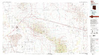 1994 Willcox1994 Print · USGSSoutheast Arizona in the mid-nineties shows a landscape defined by expansive desert basins and rugged sky islands. Genealogists and historians can trace the rail corridor of the Southern Pacific through Willcox, Bowie, and the Kansas Settlement.2 unique versions available
 - 1996 Map of Bowie, 2002 Print
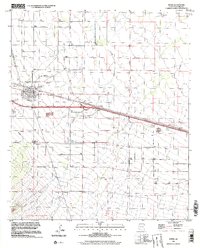 1996 Bowie2002 Print · USGSBowie sits at the intersection of desert rail and road networks in the mid-1990s, serving as a vital hub in Cochise County. Researchers can trace the town's layout from the High Sch to the Desert Rest (Cem), alongside the vital Southern Pacific railroad.
End of results
Showing maps 1-2 of 2
Frequently asked questions
- What are the different types of historical maps available for Bowie?
- What is the oldest map of Bowie?
- Where can I purchase historical maps of Bowie for my home or office?
- Where can I download high-res historical maps of Bowie?
- Are there historical topographic maps available for Bowie?
- Is there historical aerial imagery available for Bowie?
- Where are historical maps of Bowie sourced from?