1910s Maps of Douglas, Arizona
Explore 4 historic maps of Douglas from the 1910s. These maps offer a rare glimpse into what life looked like during the 1910s — showing old roads, neighborhoods, homes, and landmarks that have changed or disappeared over time.
Whether you're researching your family's past, planning a metal detecting trip, or studying how Douglas's landscape evolved across the 1910s, these high-resolution maps are a powerful tool for exploring the history of this region.
- Focus on a specific era: All maps on this page are from the 1910s, giving you a focused view of this time period.
- See what’s changed: Compare century-old streets, trails, and buildings to today's modern landscape using overlays and satellite layers.
- Research with precision: Use these maps for genealogy, historical research, land use analysis, or educational projects.
- View, download, or print: Maps are fully viewable online in high resolution, and can be downloaded or printed for your own records.
Start exploring Douglas's history through authentic maps from the 1910s. This is your window into the past.
Douglas, AZ maps
(4)- 1914 Map of Douglas
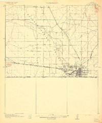 1914 Douglas1914 Print · USGSThe copper-smelting industry dominates the landscape near the international border just before the Great War. Genealogists and historians can trace the early foundations of Douglas, the grid of Pirtleville, and rural landmarks like Carey Ranch and Valley School.3 unique versions available
 - 1916 Map of Douglas
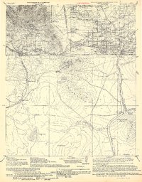 1916 Douglas1916 Print · USGSThe Arizona-Mexico border comes alive in the mid-1910s, showcasing the height of the copper mining era around Bisbee and Douglas. Genealogists and historians can trace family land like Forrests Ranch and local institutions like the Double Adobe Valley School.
 - 1919 Map of Douglas
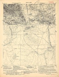 1919 Douglas1919 Print · USGSThe Arizona-Mexico borderlands come alive in the decade following the turn of the century, showing the dense mining and rail networks around the Mule Mountains. Trace early ranching footprints at Forrest's Ranch, the industrial layout of Tin Town, and cross-border landmarks like Mina de Oro.
 - 1919 Map of Perilla
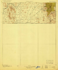 1919 Perilla1919 Print · USGSThe Arizona-Mexico borderlands come alive in this survey of the high desert ranching country. Genealogists and historians can trace family operations like the McDonald Ranch and Ed Howard Ranch, or locate the Cottonwood Creek School and Cazador Siding along the old rail line.4 unique versions available
End of results
Showing maps 1-4 of 4
Top cities near Douglas
Frequently asked questions
- What are the different types of historical maps available for Douglas?
- What is the oldest map of Douglas?
- Where can I purchase historical maps of Douglas for my home or office?
- Where can I download high-res historical maps of Douglas?
- Are there historical topographic maps available for Douglas?
- Is there historical aerial imagery available for Douglas?
- Where are historical maps of Douglas sourced from?