1970s Maps of Bonita Creek Estates, Arizona
Explore 1 historic maps of Bonita Creek Estates from the 1970s. These maps offer a rare glimpse into what life looked like during the 1970s — showing old roads, neighborhoods, homes, and landmarks that have changed or disappeared over time.
Whether you're researching your family's past, planning a metal detecting trip, or studying how Bonita Creek Estates's landscape evolved across the 1970s, these high-resolution maps are a powerful tool for exploring the history of this region.
- Focus on a specific era: All maps on this page are from the 1970s, giving you a focused view of this time period.
- See what’s changed: Compare century-old streets, trails, and buildings to today's modern landscape using overlays and satellite layers.
- Research with precision: Use these maps for genealogy, historical research, land use analysis, or educational projects.
- View, download, or print: Maps are fully viewable online in high resolution, and can be downloaded or printed for your own records.
Start exploring Bonita Creek Estates's history through authentic maps from the 1970s. This is your window into the past.
Bonita Creek Estates, AZ maps
(1)- 1972 Map of Dane Canyon, 1974 Print
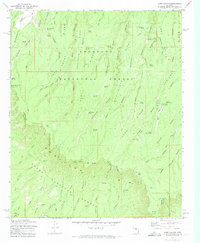 1972 Dane Canyon1974 Print · USGSThe Mogollon Rim divides the Coconino and Tonto National Forests in the early 1970s. Researchers can locate remote historical sites like the Holder Cabin (Site), the Battle of Big Dry Wash Historical Marker, and the Buck Springs Guard Station.3 unique versions available
End of results
Showing maps 1-1 of 1
Top cities near Bonita Creek Estates
Frequently asked questions
- What are the different types of historical maps available for Bonita Creek Estates?
- What is the oldest map of Bonita Creek Estates?
- Where can I purchase historical maps of Bonita Creek Estates for my home or office?
- Where can I download high-res historical maps of Bonita Creek Estates?
- Are there historical topographic maps available for Bonita Creek Estates?
- Is there historical aerial imagery available for Bonita Creek Estates?
- Where are historical maps of Bonita Creek Estates sourced from?