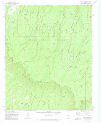
1972 Map of Dane Canyon
USGS Topo · Published 1974About this map
The Mogollon Rim escarpment dominates this 1970s survey, marking the dramatic geological boundary between the Coconino National Forest and the Tonto National Forest. This high-altitude landscape is defined by a dense network of ridges and canyons, such as Dane Canyon and Leonard Canyon, which serve as critical drainage systems for the plateau. The map identifies the Battle of Big Dry Wash Historical Marker, commemorating the 1882 conflict, alongside remote outposts like the Buck Springs Guard Station and the Holder Cabin (Site). Water sources are essential in this environment, as seen in the numerous named springs including General Springs and McClintock Spring. Pack trails and early infrastructure, such as the Highline Trail and a Telephone Line, illustrate how these lands were managed and navigated before the expansion of modern road systems.
Find a feature on this map
70 named features on this map. Tap any name to fly to it.
Don’t see what you’re looking for? This feature index may not catch every label — zoom into the map to look around manually.
Map Details
Editions of this 1972 Dane Canyon Map
3 editions found
Other maps of this area

1887 · Verde
USGS Topo · 1:250,000

1892 · Verde
USGS Topo · 1:250,000

1934 · Pine
USGS Topo · 1:62,500

1934 · Promontory Butte
USGS Topo · 1:62,500

1939 · Promontory Butte
USGS Topo · 1:62,500

1940 · Pine
USGS Topo · 1:62,500

1952 · Pine
USGS Topo · 1:62,500

1952 · Promontory Butte
USGS Topo · 1:62,500

1954 · Holbrook
USGS Topo · 1:250,000

1957 · Holbrook
USGS Topo · 1:250,000