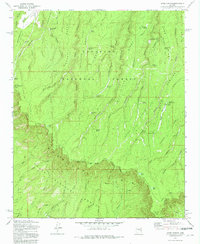
1972 Map of Dane Canyon
USGS Topo · Published 1982About this map
The Mogollon Rim marks a dramatic geological divide across this 1972 survey, separating the Coconino National Forest on the high plateau from the Tonto National Forest below. This escarpment defines the landscape, with deep drainages like Dane Canyon and Leonard Canyon cutting through the terrain. The map records important markers of frontier history, including the Battle of Big Dry Wash Historical Marker near General Springs, commemorating one of the final major conflicts between the U.S. Cavalry and the Apache. Settlement traces are sparse but significant for local history, featuring the Buck Springs Guard Station and the Holder Cabin (Site). A dense network of springs, such as Whistling Spring and Barbershop Spring, provides vital water sources in this high-altitude environment, while the presence of the Highline Trail and Control Road suggests the early infrastructure developed for forest management and ranching.
Find a feature on this map
70 named features on this map. Tap any name to fly to it.
Don’t see what you’re looking for? This feature index may not catch every label — zoom into the map to look around manually.
Map Details
Editions of this 1972 Dane Canyon Map
3 editions found
Other maps of this area

1887 · Verde
USGS Topo · 1:250,000

1892 · Verde
USGS Topo · 1:250,000

1934 · Pine
USGS Topo · 1:62,500

1934 · Promontory Butte
USGS Topo · 1:62,500

1939 · Promontory Butte
USGS Topo · 1:62,500

1940 · Pine
USGS Topo · 1:62,500

1952 · Pine
USGS Topo · 1:62,500

1952 · Promontory Butte
USGS Topo · 1:62,500

1954 · Holbrook
USGS Topo · 1:250,000

1957 · Holbrook
USGS Topo · 1:250,000