1910s Maps of Coolidge Dam, Arizona
Explore 2 historic maps of Coolidge Dam from the 1910s. These maps offer a rare glimpse into what life looked like during the 1910s — showing old roads, neighborhoods, homes, and landmarks that have changed or disappeared over time.
Whether you're researching your family's past, planning a metal detecting trip, or studying how Coolidge Dam's landscape evolved across the 1910s, these high-resolution maps are a powerful tool for exploring the history of this region.
- Focus on a specific era: All maps on this page are from the 1910s, giving you a focused view of this time period.
- See what’s changed: Compare century-old streets, trails, and buildings to today's modern landscape using overlays and satellite layers.
- Research with precision: Use these maps for genealogy, historical research, land use analysis, or educational projects.
- View, download, or print: Maps are fully viewable online in high resolution, and can be downloaded or printed for your own records.
Start exploring Coolidge Dam's history through authentic maps from the 1910s. This is your window into the past.
Coolidge Dam, AZ maps
(2)- 1915 Map of Christmas, 1957 Print
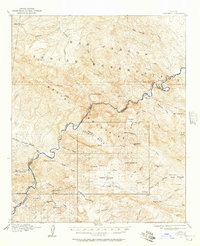 1915 Christmas1957 Print · USGSThe Gila River canyon and Mescal Mountains are shown here during the peak of early Arizona mining and ranching. Genealogists and historians can trace the foundations of the Christmas settlement, the Arizona Eastern rail line, and remote sites like Mings Ranch or the Lower Coal Field Mine.2 unique versions available
 - 1917 Map of Christmas
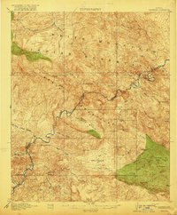 1917 Christmas1917 Print · USGSMining camps and desert ranching take center stage in this Gila County survey conducted just after the turn of the century. Genealogists and historians can trace the early footprint of Christmas and the various mineral works of the region, from the Lee Mine to the Old Mill.3 unique versions available
End of results
Showing maps 1-2 of 2
Top cities near Coolidge Dam
Frequently asked questions
- What are the different types of historical maps available for Coolidge Dam?
- What is the oldest map of Coolidge Dam?
- Where can I purchase historical maps of Coolidge Dam for my home or office?
- Where can I download high-res historical maps of Coolidge Dam?
- Are there historical topographic maps available for Coolidge Dam?
- Is there historical aerial imagery available for Coolidge Dam?
- Where are historical maps of Coolidge Dam sourced from?