1900s (20th Century) Maps of Roosevelt Lake Estates, Arizona
Explore 10 historic maps of Roosevelt Lake Estates from the 1900s (20th Century). These maps offer a rare glimpse into what life looked like during the 1900s — showing old roads, neighborhoods, homes, and landmarks that have changed or disappeared over time.
Whether you're researching your family's past, planning a metal detecting trip, or studying how Roosevelt Lake Estates's landscape evolved across the 1900s, these high-resolution maps are a powerful tool for exploring the history of this region.
- Focus on a specific era: All maps on this page are from the 1900s, giving you a focused view of this time period.
- See what’s changed: Compare century-old streets, trails, and buildings to today's modern landscape using overlays and satellite layers.
- Research with precision: Use these maps for genealogy, historical research, land use analysis, or educational projects.
- View, download, or print: Maps are fully viewable online in high resolution, and can be downloaded or printed for your own records.
Start exploring Roosevelt Lake Estates's history through authentic maps from the 1900s. This is your window into the past.
Roosevelt Lake Estates, AZ maps
(10)- 1907 Map of Roosevelt, 1956 Print
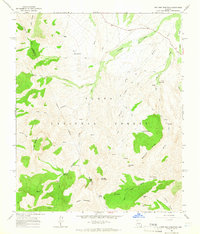
 1907 Roosevelt1956 Print · USGSCentral Arizona at the birth of the reclamation era centers on the engineering of the Roosevelt Dam and the waters of the Salt River. Genealogists and historians can trace numerous early family holdings like Clanton's Ranch, the stage stop at Schells Station, and the remote settlement of Apacheria.2 unique versions available
 - 1909 Map of Four Peaks
 1909 Four Peaks1909 Print · USGSThe central Arizona wilderness at the start of the century reveals a land of isolated ranching outposts and rugged mountain passes. Researchers can trace the early cattle frontier at Sunflower Ranch, find the original Mormon Flats, and locate the historic Schells Station.2 unique versions available
 - 1912 Map of Roosevelt
 1912 Roosevelt1912 Print · USGSCentral Arizona is captured here during the transformative years following the completion of the Roosevelt Dam. You can trace early ranching homesteads such as Clines Ranch and Howell's Ranch or locate the site of Schell's Station.4 unique versions available
 - 1954 Map of Mesa, 1968 Print
 1954 Mesa1968 Print · USGSCentral Arizona in the mid-fifties reveals the rapid growth of the Valley of the Sun alongside the deep-rooted mining districts of the eastern mountains. Genealogists and researchers can trace the expansion of Mesa and Chandler or locate legacy operations at Inspiration Mine and the Magma Arizona railroad.4 unique versions available
 - 1957 Map of Mesa
 1957 Mesa1957 Print · USGSCentral Arizona's desert valleys and high-mountain mining districts come alive in the mid-fifties. Researchers can trace the early layout of Mesa and Phoenix or locate remote sites like Inspiration Mine and Arizona State College.
 - 1958 Map of Mesa
 1958 Mesa1958 Print · USGSMid-century Arizona comes alive in this survey of the valley and high desert, where urban growth begins to transform the landscape. Genealogists and researchers can trace the rail-and-mine economy through Inspiration Mine and old stops like Rittenhouse and Magma.
 - 1960 Map of Mesa
 1960 Mesa1960 Print · USGSThe Salt River Valley and Superstition wilderness are captured here during a era of rapid post-war growth. Researchers can trace the mid-century footprints of Williams AF Base and Arizona State College or locate the deep-rock shafts of the Old Dominion Mine and Magma Mine.
 - 1964 Map of Mesa
 1964 Mesa1964 Print · USGSCentral Arizona in the mid-1960s reveals a landscape defined by rapid desert urbanization and a massive copper mining industry. Genealogists and historians can trace the growth of Phoenix or explore the mining camps and operations at Miami Mine and Magma Mine.
 - 1964 Map of Two Bar Mountain, 1965 Print
 1964 Two Bar Mountain1965 Print · USGSThe Tonto National Forest backcountry in the 1960s was a landscape of isolated ranching and steep ridges. Researchers can locate remote outposts like Two Bar Ranch, the old Schoolhouse, and landmarks like Nonesuch Rocks and the Apache Trail.3 unique versions available
 - 1994 Map of Theodore Roosevelt Lake, 1995 Print
 1994 Theodore Roosevelt Lake1995 Print · USGSCentral Arizona in the early nineties reveals the sprawling growth of the Valley of the Sun against the high desert wilderness. Researchers can trace the development of Scottsdale and Carefree or locate remote outposts like Sunflower and Punkin Center near the Mazatzal Wilderness.3 unique versions available
End of results
Showing maps 1-10 of 10
Top cities near Roosevelt Lake Estates
Frequently asked questions
- What are the different types of historical maps available for Roosevelt Lake Estates?
- What is the oldest map of Roosevelt Lake Estates?
- Where can I purchase historical maps of Roosevelt Lake Estates for my home or office?
- Where can I download high-res historical maps of Roosevelt Lake Estates?
- Are there historical topographic maps available for Roosevelt Lake Estates?
- Is there historical aerial imagery available for Roosevelt Lake Estates?
- Where are historical maps of Roosevelt Lake Estates sourced from?