1990s Maps of Thatcher, Arizona
Explore 3 historic maps of Thatcher from the 1990s. These maps offer a rare glimpse into what life looked like during the 1990s — showing old roads, neighborhoods, homes, and landmarks that have changed or disappeared over time.
Whether you're researching your family's past, planning a metal detecting trip, or studying how Thatcher's landscape evolved across the 1990s, these high-resolution maps are a powerful tool for exploring the history of this region.
- Focus on a specific era: All maps on this page are from the 1990s, giving you a focused view of this time period.
- See what’s changed: Compare century-old streets, trails, and buildings to today's modern landscape using overlays and satellite layers.
- Research with precision: Use these maps for genealogy, historical research, land use analysis, or educational projects.
- View, download, or print: Maps are fully viewable online in high resolution, and can be downloaded or printed for your own records.
Start exploring Thatcher's history through authentic maps from the 1990s. This is your window into the past.
Thatcher, AZ maps
(3)- 1994 Map of Safford
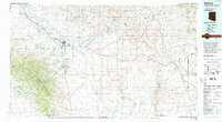 1994 Safford1994 Print · USGSSoutheastern Arizona and the New Mexico borderlands come into focus in the mid-1990s, highlighting the irrigation-fed life of the Gila Valley. Genealogists and researchers can trace local landmarks like Eastern Arizona College, the Southern Pacific RR, and settlements from Artesia to Virden.2 unique versions available
 - 1997 Map of Thatcher, 2002 Print
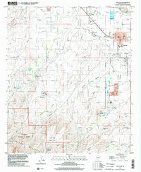 1997 Thatcher2002 Print · USGSThe Gila River valley in the late 1990s shows a landscape balancing desert agriculture and mountain wilderness. Genealogists and historians can trace the growth of Thatcher, explore the Eastern Arizona Jr College campus, or locate family plots near Central at the local Cem.
 - 1998 Map of Safford, 2002 Print
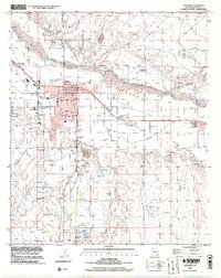 1998 Safford2002 Print · USGSSafford and Thatcher thrived along the Gila River in the late nineties, anchored by a massive network of desert irrigation. Local historians can trace the exact paths of the Union Canal and Highline Canal or locate landmarks like the Fairground and Solomon.
End of results
Showing maps 1-3 of 3
Top cities near Thatcher
- Safford historical maps
- Pima historical maps
- Swift Trail Junction historical maps
- Cactus Flat historical maps
- Central historical maps
- Solomon historical maps
See more
Frequently asked questions
- What are the different types of historical maps available for Thatcher?
- What is the oldest map of Thatcher?
- Where can I purchase historical maps of Thatcher for my home or office?
- Where can I download high-res historical maps of Thatcher?
- Are there historical topographic maps available for Thatcher?
- Is there historical aerial imagery available for Thatcher?
- Where are historical maps of Thatcher sourced from?