1970s Maps of Lake Havasu City, Arizona
Explore 5 historic maps of Lake Havasu City from the 1970s. These maps offer a rare glimpse into what life looked like during the 1970s — showing old roads, neighborhoods, homes, and landmarks that have changed or disappeared over time.
Whether you're researching your family's past, planning a metal detecting trip, or studying how Lake Havasu City's landscape evolved across the 1970s, these high-resolution maps are a powerful tool for exploring the history of this region.
- Focus on a specific era: All maps on this page are from the 1970s, giving you a focused view of this time period.
- See what’s changed: Compare century-old streets, trails, and buildings to today's modern landscape using overlays and satellite layers.
- Research with precision: Use these maps for genealogy, historical research, land use analysis, or educational projects.
- View, download, or print: Maps are fully viewable online in high resolution, and can be downloaded or printed for your own records.
Start exploring Lake Havasu City's history through authentic maps from the 1970s. This is your window into the past.
Lake Havasu City, AZ maps
(5)- 1970 Map of Havasu Lake, 1973 Print
 1970 Havasu Lake1973 Print · USGSThe Chemehuevi Indian Reservation meets the shoreline of Lake Havasu in the early 1970s. Researchers can locate the early layout of the Havasu Lake settlement, including Needles Ldg and various Jeep Trails heading into the Chemehuevi Valley.3 unique versions available
 - 1970 Map of Lake Havasu City South, 1973 Print
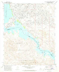 1970 Lake Havasu City South1973 Print · USGSArizona's desert landscape meets the rising waters of the Colorado River during the early 1970s expansion of Lake Havasu City. Genealogists and local historians can trace the early suburban footprint near Thompson Bay and locate landmarks like the Roulette Mine and Lake Havasu City Airport.3 unique versions available
 - 1970 Map of Crossman Peak, 1973 Print
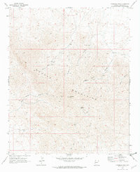 1970 Crossman Peak1973 Print · USGSThe Mohave Mountains are shown during a period of active mineral prospecting in the early seventies, accessible only by a web of primitive tracks. Researchers can trace the locations of the Sunrise Mine, Pittsburg Mine, and remote water sources like Cottonwood Spring.4 unique versions available
 - 1970 Map of Castle Rock, 1973 Print
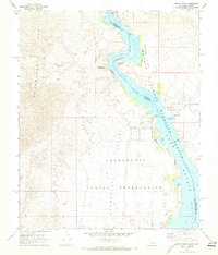 1970 Castle Rock1973 Print · USGSThe Colorado River and its transformation into Lake Havasu define this desert landscape during the early 1970s. Trace the intersection of tribal land and federal refuge while locating Picture Rock Petroglyphs, Jops Harbor, and the Chemehuevi Landing Field.2 unique versions available
 - 1970 Map of Lake Havasu City North, 1973 Print
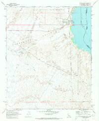
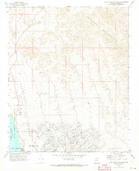 1970 Lake Havasu City North1973 Print · USGSLake Havasu City is shown in its primary stage of expansion during the early seventies, with its distinctive street grid pushing into the desert. You can trace the development of neighborhood tracts like Havasupai or locate early landmarks such as the Wing Mine and the Radio Facility.4 unique versions available
End of results
Showing maps 1-5 of 5
Top cities near Lake Havasu City
Frequently asked questions
- What are the different types of historical maps available for Lake Havasu City?
- What is the oldest map of Lake Havasu City?
- Where can I purchase historical maps of Lake Havasu City for my home or office?
- Where can I download high-res historical maps of Lake Havasu City?
- Are there historical topographic maps available for Lake Havasu City?
- Is there historical aerial imagery available for Lake Havasu City?
- Where are historical maps of Lake Havasu City sourced from?