1990s Maps of Overgaard, Arizona
Explore 2 historic maps of Overgaard from the 1990s. These maps offer a rare glimpse into what life looked like during the 1990s — showing old roads, neighborhoods, homes, and landmarks that have changed or disappeared over time.
Whether you're researching your family's past, planning a metal detecting trip, or studying how Overgaard's landscape evolved across the 1990s, these high-resolution maps are a powerful tool for exploring the history of this region.
- Focus on a specific era: All maps on this page are from the 1990s, giving you a focused view of this time period.
- See what’s changed: Compare century-old streets, trails, and buildings to today's modern landscape using overlays and satellite layers.
- Research with precision: Use these maps for genealogy, historical research, land use analysis, or educational projects.
- View, download, or print: Maps are fully viewable online in high resolution, and can be downloaded or printed for your own records.
Start exploring Overgaard's history through authentic maps from the 1990s. This is your window into the past.
Overgaard, AZ maps
(2)- 1990 Map of Heber, 1991 Print
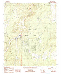 1990 Heber1991 Print · USGSHeber and Overgaard appear as thriving mountain communities during the 1980s, set against the backdrop of the Sitgreaves National Forest. Local historians can trace town developments near Tall Timbers County Park, the Overgaard Airport, and the Heber Ranger Station.
 - 1998 Map of Heber, 2000 Print
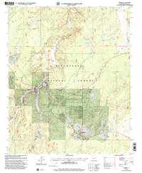 1998 Heber2000 Print · USGSThe adjacent communities of Heber and Overgaard sit amidst the high plateaus of the Sitgreaves National Forest in the late nineties. Researchers can trace the layout of family lands like Crandell Ranch and local landmarks including the Tall Timbers Cemetery.
End of results
Showing maps 1-2 of 2
Frequently asked questions
- What are the different types of historical maps available for Overgaard?
- What is the oldest map of Overgaard?
- Where can I purchase historical maps of Overgaard for my home or office?
- Where can I download high-res historical maps of Overgaard?
- Are there historical topographic maps available for Overgaard?
- Is there historical aerial imagery available for Overgaard?
- Where are historical maps of Overgaard sourced from?