1980s Maps of Winslow, Arizona
Explore 3 historic maps of Winslow from the 1980s. These maps offer a rare glimpse into what life looked like during the 1980s — showing old roads, neighborhoods, homes, and landmarks that have changed or disappeared over time.
Whether you're researching your family's past, planning a metal detecting trip, or studying how Winslow's landscape evolved across the 1980s, these high-resolution maps are a powerful tool for exploring the history of this region.
- Focus on a specific era: All maps on this page are from the 1980s, giving you a focused view of this time period.
- See what’s changed: Compare century-old streets, trails, and buildings to today's modern landscape using overlays and satellite layers.
- Research with precision: Use these maps for genealogy, historical research, land use analysis, or educational projects.
- View, download, or print: Maps are fully viewable online in high resolution, and can be downloaded or printed for your own records.
Start exploring Winslow's history through authentic maps from the 1980s. This is your window into the past.
Winslow, AZ maps
(3)- 1980 Map of Holbrook, 1996 Print
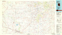
 1980 Holbrook1996 Print · USGSHolbrook and the surrounding Navajo County high desert are captured here in the early eighties, showcasing a landscape of rail-driven commerce and ranching. Researchers can trace the Atchison Topeka and Santa Fe RR through Penzance or locate historical points like Mormon Crossing and Rock Station.2 unique versions available
 - 1982 Map of Winslow, 1983 Print
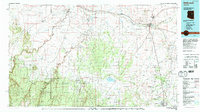
 1982 Winslow1983 Print · USGSThe High Desert of Northern Arizona in the early eighties shows the intersection of tribal lands and railroad history. Genealogists and historians can locate remote settlements like Leupp and Indian Wells or trace the Atchison Topeka and Santa Fe line past Bushman Acres.2 unique versions available
 - 1986 Map of Winslow
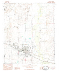 1986 Winslow1986 Print · USGSWinslow is shown during the mid-1980s as a thriving rail and regional center along the Little Colorado River. Genealogists and researchers can trace the city's growth around the Atchison Topeka and Santa Fe railroad and the Northland Pioneer College campus.
End of results
Showing maps 1-3 of 3
Top cities near Winslow
Top neighborhoods of Winslow
Frequently asked questions
- What are the different types of historical maps available for Winslow?
- What is the oldest map of Winslow?
- Where can I purchase historical maps of Winslow for my home or office?
- Where can I download high-res historical maps of Winslow?
- Are there historical topographic maps available for Winslow?
- Is there historical aerial imagery available for Winslow?
- Where are historical maps of Winslow sourced from?