1950s Maps of Winslow, Arizona
Explore 7 historic maps of Winslow from the 1950s. These maps offer a rare glimpse into what life looked like during the 1950s — showing old roads, neighborhoods, homes, and landmarks that have changed or disappeared over time.
Whether you're researching your family's past, planning a metal detecting trip, or studying how Winslow's landscape evolved across the 1950s, these high-resolution maps are a powerful tool for exploring the history of this region.
- Focus on a specific era: All maps on this page are from the 1950s, giving you a focused view of this time period.
- See what’s changed: Compare century-old streets, trails, and buildings to today's modern landscape using overlays and satellite layers.
- Research with precision: Use these maps for genealogy, historical research, land use analysis, or educational projects.
- View, download, or print: Maps are fully viewable online in high resolution, and can be downloaded or printed for your own records.
Start exploring Winslow's history through authentic maps from the 1950s. This is your window into the past.
Winslow, AZ maps
(7)- 1954 Map of Winslow, 1956 Print
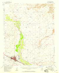 1954 Winslow1956 Print · USGSIn the mid-fifties, Winslow thrived as a vital rail and aviation crossroads along the Little Colorado River. Researchers can trace the layout of Winslow and Bushman Acres, the facilities at Winslow Municipal Airport, and the Atchison Topeka and Santa Fe tracks.2 unique versions available
 - 1954 Map of Winslow 4 SW, 1957 Print
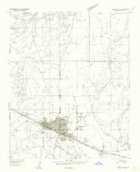 1954 Winslow 4 SW1957 Print · USGSThe railroad town of Winslow is captured in the mid-fifties as a bustling Route 66 hub. Researchers can trace family-named sites, early aviation at the Winslow Municipal Airport, and local landmarks like the Drive-in Theater.
 - 1954 Map of Flagstaff, 1966 Print
 1954 Flagstaff1966 Print · USGSNorthern Arizona in the mid-fifties shows a landscape of volcanic peaks and ancestral mesa villages linked by the iconic U.S. 66. Trace the path of the Atchison Topeka and Santa Fe through Winslow or explore the settlements of Old Oraibi and Kearns Canyon.3 unique versions available
 - 1954 Map of Holbrook, 1966 Print
 1954 Holbrook1966 Print · USGSNorth-central Arizona is seen here during the mid-fifties, from the high plateau of the Mogollon Rim to the Verde Valley. Researchers can trace the early growth of Holbrook, locate remote camps like Happy Jack, and explore the roads around Montezuma Castle National Monument.3 unique versions available
 - 1957 Map of Holbrook
 1957 Holbrook1957 Print · USGSNorthern Arizona in the mid-fifties is defined by the high-plateau timberlands and the bustling rail corridor of the Little Colorado River valley. Genealogists and historians can trace the route of U.S. 66 through Holbrook or locate more remote outposts like Zeniff and Aripine.
 - 1958 Map of Flagstaff
 1958 Flagstaff1958 Print · USGSNorthern Arizona in the late fifties is captured here during the heyday of Route 66 and the expansion of the high desert rail corridors. Researchers can trace historic mesa settlements like Old Oraibi or follow the path of the Atchison Topeka and Santa Fe through Flagstaff and Winslow.
 - 1958 Map of Holbrook
 1958 Holbrook1958 Print · USGSNortheastern Arizona's high country is captured here during the mid-fifties, showing the growth of mountain towns and timber lands. Researchers can trace the Atchison Topeka & Santa Fe RR through Holbrook or find vanished spots like Zeniff.
End of results
Showing maps 1-7 of 7
Top cities near Winslow
Top neighborhoods of Winslow
Frequently asked questions
- What are the different types of historical maps available for Winslow?
- What is the oldest map of Winslow?
- Where can I purchase historical maps of Winslow for my home or office?
- Where can I download high-res historical maps of Winslow?
- Are there historical topographic maps available for Winslow?
- Is there historical aerial imagery available for Winslow?
- Where are historical maps of Winslow sourced from?