1990s Maps of Ajo Terrace, Pima County
Explore 4 historic maps of Ajo Terrace from the 1990s. These maps offer a rare glimpse into what life looked like during the 1990s — showing old roads, neighborhoods, homes, and landmarks that have changed or disappeared over time.
Whether you're researching your family's past, planning a metal detecting trip, or studying how Ajo Terrace's landscape evolved across the 1990s, these high-resolution maps are a powerful tool for exploring the history of this region.
- Focus on a specific era: All maps on this page are from the 1990s, giving you a focused view of this time period.
- See what’s changed: Compare century-old streets, trails, and buildings to today's modern landscape using overlays and satellite layers.
- Research with precision: Use these maps for genealogy, historical research, land use analysis, or educational projects.
- View, download, or print: Maps are fully viewable online in high resolution, and can be downloaded or printed for your own records.
Start exploring Ajo Terrace's history through authentic maps from the 1990s. This is your window into the past.
Ajo Terrace, Pima County maps
(4)- 1990 Map of Childs Mountain, 1991 Print
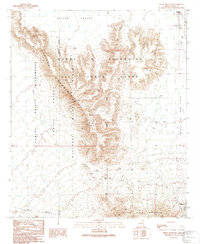 1990 Childs Mountain1991 Print · USGSPima County's arid frontier is mapped here in the early 1990s as it transitions from the Air Force range into protected wilderness. Researchers can locate the settlement of Gibson and trace desert water sources like Pozo Salado and Dunns Well among scattered Prospects.
 - 1990 Map of Ajo North, 1991 Print
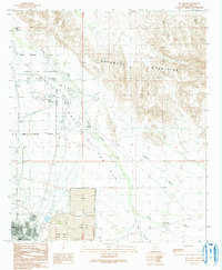 1990 Ajo North1991 Print · USGSNear the close of the century, the Arizona desert north of Ajo was a landscape of military boundaries and industrial tailing ponds. Researchers can trace the layout of the Barry M Goldwater Air Force Range and local landmarks like Childs, the Ajo Country Club, and the Cem.
 - 1996 Map of Childs Mountain, 2000 Print
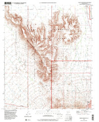 1996 Childs Mountain2000 Print · USGSThe Pima County desert as it appeared in the late nineties showcases a landscape shaped by military activity and conservation. Researchers can trace the boundaries of the Cabeza Prieta National Wildlife Refuge alongside local landmarks like Pozo Salado and Dunns Well.
 - 1996 Map of Ajo North, 2000 Print
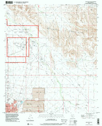 1996 Ajo North2000 Print · USGSIn the mid-nineties, this Pima County landscape shows the meeting point of desert wilderness and large-scale mining industry. Researchers can trace the layout of Ajo and Gibson alongside the massive Tailings Pond and the Ajo Municipal Airport.
End of results
Showing maps 1-4 of 4
Frequently asked questions
- What are the different types of historical maps available for Ajo Terrace?
- What is the oldest map of Ajo Terrace?
- Where can I purchase historical maps of Ajo Terrace for my home or office?
- Where can I download high-res historical maps of Ajo Terrace?
- Are there historical topographic maps available for Ajo Terrace?
- Is there historical aerial imagery available for Ajo Terrace?
- Where are historical maps of Ajo Terrace sourced from?