1930s Maps of Ajo, Arizona
Explore 2 historic maps of Ajo from the 1930s. These maps offer a rare glimpse into what life looked like during the 1930s — showing old roads, neighborhoods, homes, and landmarks that have changed or disappeared over time.
Whether you're researching your family's past, planning a metal detecting trip, or studying how Ajo's landscape evolved across the 1930s, these high-resolution maps are a powerful tool for exploring the history of this region.
- Focus on a specific era: All maps on this page are from the 1930s, giving you a focused view of this time period.
- See what’s changed: Compare century-old streets, trails, and buildings to today's modern landscape using overlays and satellite layers.
- Research with precision: Use these maps for genealogy, historical research, land use analysis, or educational projects.
- View, download, or print: Maps are fully viewable online in high resolution, and can be downloaded or printed for your own records.
Start exploring Ajo's history through authentic maps from the 1930s. This is your window into the past.
Ajo, AZ maps
(2)- 1932 Map of Ajo, 1958 Print
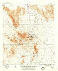 1932 Ajo1958 Print · USGSThe copper-rich Arizona desert comes alive in the early 1930s, centered on the massive pit and surrounding worker communities. Trace the rail lines of the Tucson Cornelia and Gila Bend RR or locate the historic Indian Cem and New Cornelia Mines.
 - 1934 Map of Ajo
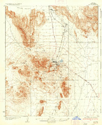 1934 Ajo1934 Print · USGSArizona's copper mining heartland comes into focus in the 1930s as industrial development expands across the desert. Genealogists and historians can trace local life at Mexican Town, locate the Indian Cem, or follow the Old Sonoita Road past remote sites like Bates Well.2 unique versions available
End of results
Showing maps 1-2 of 2
Frequently asked questions
- What are the different types of historical maps available for Ajo?
- What is the oldest map of Ajo?
- Where can I purchase historical maps of Ajo for my home or office?
- Where can I download high-res historical maps of Ajo?
- Are there historical topographic maps available for Ajo?
- Is there historical aerial imagery available for Ajo?
- Where are historical maps of Ajo sourced from?