1990s Maps of Piato Vaya, Pisinemo District
Explore 2 historic maps of Piato Vaya from the 1990s. These maps offer a rare glimpse into what life looked like during the 1990s — showing old roads, neighborhoods, homes, and landmarks that have changed or disappeared over time.
Whether you're researching your family's past, planning a metal detecting trip, or studying how Piato Vaya's landscape evolved across the 1990s, these high-resolution maps are a powerful tool for exploring the history of this region.
- Focus on a specific era: All maps on this page are from the 1990s, giving you a focused view of this time period.
- See what’s changed: Compare century-old streets, trails, and buildings to today's modern landscape using overlays and satellite layers.
- Research with precision: Use these maps for genealogy, historical research, land use analysis, or educational projects.
- View, download, or print: Maps are fully viewable online in high resolution, and can be downloaded or printed for your own records.
Start exploring Piato Vaya's history through authentic maps from the 1990s. This is your window into the past.
Piato Vaya, Pisinemo District maps
(2)- 1990 Map of Ben Nevis Mountain
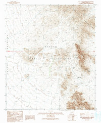 1990 Ben Nevis Mountain1990 Print · USGSThe Papago Indian Reservation and the Quijotoa Mountains are documented here during the late twentieth century. Researchers can trace historical mining operations at the Quijotoa Mine, Weldon Mine, and the remote settlement of Plato Vaya.
 - 1996 Map of Ben Nevis Mountain, 2001 Print
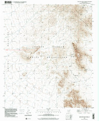 1996 Ben Nevis Mountain2001 Print · USGSThe Tohono O'odham Reservation in the mid-1990s reflects a landscape of desert mining and remote settlements. Researchers can trace the extensive workings of the Quijotoa Mine, the Ben Lomond Mines, and the community at Plato Vaya.
End of results
Showing maps 1-2 of 2
Frequently asked questions
- What are the different types of historical maps available for Piato Vaya?
- What is the oldest map of Piato Vaya?
- Where can I purchase historical maps of Piato Vaya for my home or office?
- Where can I download high-res historical maps of Piato Vaya?
- Are there historical topographic maps available for Piato Vaya?
- Is there historical aerial imagery available for Piato Vaya?
- Where are historical maps of Piato Vaya sourced from?