1960s Maps of San Xavier District, Arizona
Explore 6 historic maps of San Xavier District from the 1960s. These maps offer a rare glimpse into what life looked like during the 1960s — showing old roads, neighborhoods, homes, and landmarks that have changed or disappeared over time.
Whether you're researching your family's past, planning a metal detecting trip, or studying how San Xavier District's landscape evolved across the 1960s, these high-resolution maps are a powerful tool for exploring the history of this region.
- Focus on a specific era: All maps on this page are from the 1960s, giving you a focused view of this time period.
- See what’s changed: Compare century-old streets, trails, and buildings to today's modern landscape using overlays and satellite layers.
- Research with precision: Use these maps for genealogy, historical research, land use analysis, or educational projects.
- View, download, or print: Maps are fully viewable online in high resolution, and can be downloaded or printed for your own records.
Start exploring San Xavier District's history through authentic maps from the 1960s. This is your window into the past.
San Xavier District, AZ maps
(6)- 1962 Map of Tucson
 1962 Tucson1962 Print · USGSSouthern Arizona in the early sixties showcases a landscape defined by burgeoning desert cities and massive military installations. Researchers can trace tribal settlements like Schuchk, legacy mining sites at Silver Bell Mine, and the early footprint of Davis-Monthan Air Force Base.
 - 1964 Map of Tucson
 1964 Tucson1964 Print · USGSSouthern Arizona in the mid-1960s shows a landscape of burgeoning desert cities and industrial-scale copper mining. Researchers can trace the development of Tucson and its outlying mining districts, including the Silver Bell Mine and San Manuel Mine.
 - 1968 Map of Tucson SW, 1969 Print
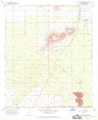
 1968 Tucson SW1969 Print · USGSSouth of the Tucson city limits in the late sixties, this aerial survey captures the desert valley as it transitioned between traditional ranching and modern aviation. Genealogists and researchers can trace the limits of the San Xavier Indian Reservation and locate landmarks like Martinez Hill and the Tucson International Airport.3 unique versions available
 - 1968 Map of San Xavier Mission, 1970 Print
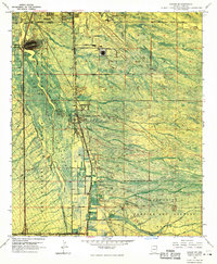
 1968 San Xavier Mission1970 Print · USGSThe Santa Cruz Valley was undergoing a major industrial transition in the late sixties as mining operations expanded near the San Xavier del Bac Mission. Researchers can trace the footprint of the San Xavier Indian Reservation and locate old landmarks like the Powder Magazine and Lava Knoll.2 unique versions available
 - 1968 Map of Cat Mountain, 1970 Print
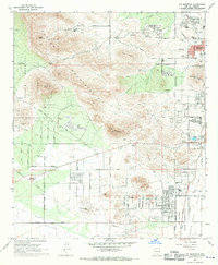 1968 Cat Mountain1970 Print · USGSWestward growth from the city of Tucson into the rugged foothills is captured here during the late sixties. Researchers can trace the development of suburban neighborhoods and schools like Tully Sch alongside landmarks such as St Marys Hospital and Tumamoc Hill.2 unique versions available
 - 1968 Map of San Xavier Mission SW, 1970 Print
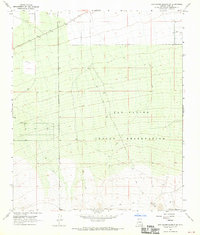 1968 San Xavier Mission SW1970 Print · USGSThe southwestern reaches of the San Xavier Indian Reservation are documented here in the late sixties as a landscape of remote ranching and desert trails. Researchers can trace rural landmarks like J Bar M, the route of Sandario Road, and early water infrastructure at Huff.2 unique versions available
End of results
Showing maps 1-6 of 6
Top cities near San Xavier District
Top neighborhoods of San Xavier District
Frequently asked questions
- What are the different types of historical maps available for San Xavier District?
- What is the oldest map of San Xavier District?
- Where can I purchase historical maps of San Xavier District for my home or office?
- Where can I download high-res historical maps of San Xavier District?
- Are there historical topographic maps available for San Xavier District?
- Is there historical aerial imagery available for San Xavier District?
- Where are historical maps of San Xavier District sourced from?