1990s Maps of Tortolita, Arizona
Explore 3 historic maps of Tortolita from the 1990s. These maps offer a rare glimpse into what life looked like during the 1990s — showing old roads, neighborhoods, homes, and landmarks that have changed or disappeared over time.
Whether you're researching your family's past, planning a metal detecting trip, or studying how Tortolita's landscape evolved across the 1990s, these high-resolution maps are a powerful tool for exploring the history of this region.
- Focus on a specific era: All maps on this page are from the 1990s, giving you a focused view of this time period.
- See what’s changed: Compare century-old streets, trails, and buildings to today's modern landscape using overlays and satellite layers.
- Research with precision: Use these maps for genealogy, historical research, land use analysis, or educational projects.
- View, download, or print: Maps are fully viewable online in high resolution, and can be downloaded or printed for your own records.
Start exploring Tortolita's history through authentic maps from the 1990s. This is your window into the past.
Tortolita, AZ maps
(3)- 1992 Map of Ruelas Canyon, 1995 Print
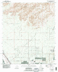 1992 Ruelas Canyon1995 Print · USGSThe Pima County desert as it appeared in the early nineties shows the growing suburbs of Maraña meeting the rugged Tortolita Mountains. Local historians can trace old landmarks like the Cem near the Santa Cruz River and the rural Landing Strip out by Canada del Oro.
 - 1994 Map of Silver Bell Mountains
 1994 Silver Bell Mountains1994 Print · USGSSouthern Arizona in the mid-nineties shows a land of transition between desert wilderness, tribal lands, and the growing Tucson suburbs. Genealogists and historians can trace settlements like San Luis and Ko Vaya, or follow the industrial legacy of the Silver Bell Mine.2 unique versions available
 - 1996 Map of Ruelas Canyon, 2002 Print
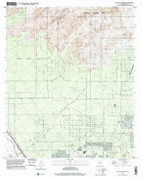 1996 Ruelas Canyon2002 Print · USGSThe northern Tucson periphery enters a period of significant suburban expansion in the late nineties. Trace the growth of Oro Valley and its surrounding desert parks, from the rugged heights of Tortolita Mountain Park to the banks of the Santa Cruz River.
End of results
Showing maps 1-3 of 3
Top cities near Tortolita
- Tucson historical maps
- Marana historical maps
- Oro Valley historical maps
- Saddlebrooke historical maps
- Picture Rocks historical maps
- Catalina historical maps
See more
Frequently asked questions
- What are the different types of historical maps available for Tortolita?
- What is the oldest map of Tortolita?
- Where can I purchase historical maps of Tortolita for my home or office?
- Where can I download high-res historical maps of Tortolita?
- Are there historical topographic maps available for Tortolita?
- Is there historical aerial imagery available for Tortolita?
- Where are historical maps of Tortolita sourced from?