1990s Maps of Palo Verde Park, Tucson
Explore 3 historic maps of Palo Verde Park from the 1990s. These maps offer a rare glimpse into what life looked like during the 1990s — showing old roads, neighborhoods, homes, and landmarks that have changed or disappeared over time.
Whether you're researching your family's past, planning a metal detecting trip, or studying how Palo Verde Park's landscape evolved across the 1990s, these high-resolution maps are a powerful tool for exploring the history of this region.
- Focus on a specific era: All maps on this page are from the 1990s, giving you a focused view of this time period.
- See what’s changed: Compare century-old streets, trails, and buildings to today's modern landscape using overlays and satellite layers.
- Research with precision: Use these maps for genealogy, historical research, land use analysis, or educational projects.
- View, download, or print: Maps are fully viewable online in high resolution, and can be downloaded or printed for your own records.
Start exploring Palo Verde Park's history through authentic maps from the 1990s. This is your window into the past.
Palo Verde Park, Tucson maps
(3)- 1992 Map of Tucson East, 1995 Print
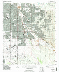 1992 Tucson East1995 Print · USGSEastern Tucson in the early nineties shows a city balancing its suburban growth with its heavy military and aviation heritage. Trace the boundaries of Davis-Monthan Air Force Base, old routes like Old Spanish Trail, and the development of Littletown.
 - 1994 Map of Tucson
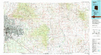 1994 Tucson1994 Print · USGSTucson and the Santa Cruz Valley appear here in the mid-1990s, caught between rapid urban growth and protected wilderness. Researchers can trace the development of Casas Adobes, the operations at Davis Monthan Air Force Base, and the rail lines of the Southern Pacific RR.2 unique versions available
 - 1996 Map of Tucson East, 2002 Print
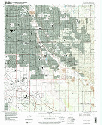 1996 Tucson East2002 Print · USGSSoutheastern Tucson enters a period of significant suburban and military expansion during the late nineties. Researchers can trace the layout of Davis-Monthan Air Force Base, find the Pima Air & Space Museum, and locate residential clusters like Littleton and Vandenberg Village.
End of results
Showing maps 1-3 of 3
Top cities near Palo Verde Park
- Tucson historical maps
- Marana historical maps
- Oro Valley historical maps
- Sahuarita historical maps
- Vail historical maps
- South Tucson historical maps
Top neighborhoods of Palo Verde Park
Frequently asked questions
- What are the different types of historical maps available for Palo Verde Park?
- What is the oldest map of Palo Verde Park?
- Where can I purchase historical maps of Palo Verde Park for my home or office?
- Where can I download high-res historical maps of Palo Verde Park?
- Are there historical topographic maps available for Palo Verde Park?
- Is there historical aerial imagery available for Palo Verde Park?
- Where are historical maps of Palo Verde Park sourced from?