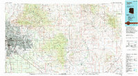
1994 Map of Tucson
USGS Topo · Published 1994About this map
Tucson and its expanding suburbs serve as the focal point of this regional landscape, bounded by massive desert preserves and mountain ranges. The urban core, including South Tucson and the Davis Monthan Air Force Base, contrasts with the high elevations of the Santa Catalina Mountains where the settlement of Summerhaven sits near Mt Lemmon. To the east, the Saguaro National Monument and Saguaro Wilderness protect the iconic saguaro forests of the Tanque Verde Ridge. The map illustrates a complex drainage system where the Santa Cruz River and Rillito Creek meet, and further east, the San Pedro River flows through a valley containing Cascabel and Redington. This 1994 edition reflects the modern infrastructure of Interstate 10 and the Southern Pacific RR corridors that define the region's transport network.
Find a feature on this map
76 named features on this map. Tap any name to fly to it.
Don’t see what you’re looking for? This feature index may not catch every label — zoom into the map to look around manually.
Map Details
Editions of this 1994 Tucson Map
2 editions found
Other maps of this area

1904 · Patagonia
USGS Topo · 1:125,000

1904 · Tucson
USGS Topo · 1:125,000

1905 · Patagonia
USGS Topo · 1:125,000

1905 · Tucson
USGS Topo · 1:125,000

1911 · Winkelman
USGS Topo · 1:125,000

1913 · Winkelman
USGS Topo · 1:125,000

1915 · Benson
USGS Topo · 1:125,000

1916 · Pearce
USGS Topo · 1:125,000

1920 · Arivaca
USGS Topo · 1:125,000

1922 · Willcox
USGS Topo · 1:125,000