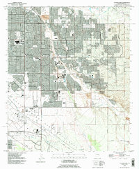
1992 Map of Tucson East
USGS Topo · Published 1995About this map
Davis-Monthan Air Force Base dominates the southern landscape of this 1992 revision, its runways and hospital facility bordered by the Southern Pacific Railroad. The map captures the suburban expansion of eastern Tucson, where established residential pockets like Vandenberg Village and Littletown meet newer developments and major shopping hubs such as Oxford Plaza Shopping Center.
Find a feature on this map
43 named features on this map. Tap any name to fly to it.
Don’t see what you’re looking for? This feature index may not catch every label — zoom into the map to look around manually.
Map Details
Editions of this 1992 Tucson East Map
This is the sole edition of this map. No revisions or reprints were ever made.
Other maps of this area

1904 · Tucson
USGS Topo · 1:125,000

1905 · Tucson
USGS Topo · 1:125,000

1948 · Tucson
USGS Topo · 1:62,500

1956 · Tucson
USGS Topo · 1:250,000

1957 · Tucson East
USGS Topo · 1:24,000

1957 · Bellota Ranch
USGS Topo · 1:62,500

1957 · Tucson
USGS Topo · 1:24,000

1957 · Tucson
USGS Topo · 1:62,500

1957 · Rincon Valley
USGS Topo · 1:62,500

1957 · Sabino Canyon
USGS Topo · 1:24,000