Old Maps of Peters Corner, Arizona for Metal Detecting
Plan your next treasure hunt with 17 historic maps of Peters Corner. Find old homesites, ghost towns, trails, and gathering spots that may be lost to time — perfect for identifying promising metal detecting locations.
- Locate forgotten sites: Uncover places like long-lost settlements, abandoned rail lines, or gathering spots.
- Plan better hunts: Use map overlays combined with LiDAR or satellite views to narrow in on historically rich areas.
- Made for detectorists: Thousands of hobbyists use these maps to discover relics, coins, and hidden history.
Use these historic maps to boost your research and find new opportunities beneath the surface of Peters Corner.
Peters Corner, AZ maps
(17)- 1946 Map of Antelope Peak, 1955 Print
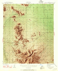 1946 Antelope Peak1955 Print · USGSThe high desert of Pinal County in the late 1940s is captured here, showing the intersection of tribal lands and the open basin. Researchers can trace early routes like Route 84 past prominent landmarks like Antelope Peak, Table Top, and the watering holes of Hidden Valley.3 unique versions available
 - 1948 Map of Antelope Peak
 1948 Antelope Peak1948 Print · USGSThe high desert south of Phoenix comes alive in the late 1940s, showing the dramatic rise of Antelope Peak and Table Top above the valley floor. Researchers can trace the early borders of the Maricopa Indian Reservation and locate isolated desert Well sites and the winding Vekol Wash.2 unique versions available
 - 1953 Map of Ajo, 1971 Print
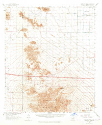
 1953 Ajo1971 Print · USGSThe Arizona desert at mid-century reveals a landscape of massive copper mines, tribal reservations, and military testing grounds. Genealogists and historians can trace rail stopovers like Dateland and Mohawk or locate remote sites like the Reward Mine and Gu Achi (Santa Rosa).2 unique versions available
 - 1957 Map of Ajo
 1957 Ajo1957 Print · USGSSouthern Arizona in the fifties reveals a landscape of massive copper mines, remote desert wells, and tribal reservations. Genealogists and historians can trace old cattle outposts like Whitewing Ranch, the Tracy's Trading Post, and the copper works at Ajo.
 - 1958 Map of Ajo
 1958 Ajo1958 Print · USGSThe high desert of Pima and Yuma Counties during the late fifties shows a landscape of remote copper mines and military flight paths. Researchers can trace the Southern Pacific Railroad through Gila Bend and find heritage sites like O'Neills Grave or the Christmas Gift Mine.2 unique versions available
 - 1962 Map of Ajo
 1962 Ajo1962 Print · USGSSouthern Arizona in the early sixties was a landscape of deep-desert mining, military airfields, and tribal lands. Researchers can trace the Cornelia Mine near Ajo, remote outposts like Trays Trading Post, and the path of the Devils Highway.
 - 1963 Map of Ajo
 1963 Ajo1963 Print · USGSSouthwestern Arizona in the early sixties reveals a landscape of desert ranches and remote mining outposts. Trace the historic Southern Pacific line or locate isolated landmarks like O'Neils Grave and Tracy's Trading Post.
 - 1963 Map of Antelope Peak, 1965 Print
 1963 Antelope Peak1965 Print · USGSThe Pinal and Maricopa County desert comes to life in the early sixties as new highways were being carved through the basin. Researchers can trace the development of Hidden Valley infrastructure, identifying prospects, a landing strip, and the prominent heights of Antelope Peak.4 unique versions available
 - 1967 Map of Ajo
 1967 Ajo1967 Print · USGSSouthern Arizona in the mid-1960s is depicted here as a landscape of military aviation and deep-desert ranching. Trace the historical mining operations at Vekol Mine or follow the Southern Pacific rail line through Gila Bend and Dateland.
 - 1971 Map of Antelope Peak NE, 1972 Print
 1971 Antelope Peak NE1972 Print · USGSPinal County agriculture is captured at its early 1970s height in this detailed orthophotoquad survey. Researchers can trace the geometric field patterns and the natural course of Vekol Wash as it existed decades ago.
 - 1981 Map of Antelope Peak NE, 1982 Print
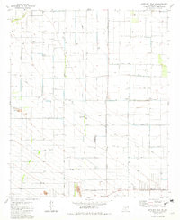 1981 Antelope Peak NE1982 Print · USGSAgricultural development and industrial infrastructure dominate this Pinal County landscape in the early eighties. Researchers can trace the layout of the Ak-Chin Indian Reservation and locate local landmarks like the Casa Grande Turbine Station and Peters Corner.2 unique versions available
 - 1981 Map of Gila Bend, 1996 Print
 1981 Gila Bend1996 Print · USGSSouthern Arizona in the early eighties reveals a vast desert corridor shaped by military ranges, indigenous lands, and historical mining. Genealogists and historians can trace rail-side settlements like Theba and Piedra or locate the historic Vekol Mine and Reward Mine.
 - 1982 Map of Ajo
 1982 Ajo1982 Print · USGSThe Arizona-Sonora borderlands come into focus in the early eighties, showcasing a landscape of desert mining towns and expansive tribal lands. Trace the Southern Pacific rail line through Gila Bend or explore the remote settlements of Ajo and Lukeville.
 - 2011 Map of Antelope Peak NE, 2011 Print
 2011 Antelope Peak NE2011 Print · USGSCovers Peters Corner, including Maricopa, Ak Chin, and other nearby areas
 - 2014 Map of Antelope Peak NE, 2014 Print
 2014 Antelope Peak NE2014 Print · USGSCovers Peters Corner, including Maricopa, Ak Chin, and other nearby areas
 - 2018 Map of Antelope Peak NE, 2018 Print
 2018 Antelope Peak NE2018 Print · USGSCovers Peters Corner, including Maricopa, Ak Chin, and other nearby areas
 - 2021 Map of Antelope Peak NE, 2021 Print
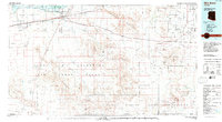
 2021 Antelope Peak NE2021 Print · USGSPinal County's desert grid comes into focus during this era of modern growth and infrastructure expansion. Researchers can trace the layout of early residential networks and local landmarks like Farms Airport and the path of Vekol Wash.
End of results
Showing maps 1-17 of 17
Top cities near Peters Corner
Frequently asked questions
- What are the different types of historical maps available for Peters Corner?
- What is the oldest map of Peters Corner?
- Where can I purchase historical maps of Peters Corner for my home or office?
- Where can I download high-res historical maps of Peters Corner?
- Are there historical topographic maps available for Peters Corner?
- Is there historical aerial imagery available for Peters Corner?
- Where are historical maps of Peters Corner sourced from?