1990s Maps of Anegam, Sif Oidak District
Explore 2 historic maps of Anegam from the 1990s. These maps offer a rare glimpse into what life looked like during the 1990s — showing old roads, neighborhoods, homes, and landmarks that have changed or disappeared over time.
Whether you're researching your family's past, planning a metal detecting trip, or studying how Anegam's landscape evolved across the 1990s, these high-resolution maps are a powerful tool for exploring the history of this region.
- Focus on a specific era: All maps on this page are from the 1990s, giving you a focused view of this time period.
- See what’s changed: Compare century-old streets, trails, and buildings to today's modern landscape using overlays and satellite layers.
- Research with precision: Use these maps for genealogy, historical research, land use analysis, or educational projects.
- View, download, or print: Maps are fully viewable online in high resolution, and can be downloaded or printed for your own records.
Start exploring Anegam's history through authentic maps from the 1990s. This is your window into the past.
Anegam, Sif Oidak District maps
(2)- 1990 Map of Santa Rosa
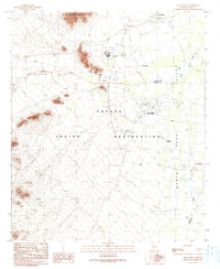 1990 Santa Rosa1990 Print · USGSThe Tohono O'odham landscape of the late twentieth century is preserved here, centered on the Papago Indian Reservation. Researchers can trace tribal infrastructure and cultural landmarks like the Childrens Shrine, Santa Rosa Trading Post, and Ak Chin.
 - 1996 Map of Santa Rosa, 2001 Print
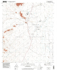 1996 Santa Rosa2001 Print · USGSThe Tohono O'odham Reservation in the mid-1990s reveals a desert landscape organized around the Santa Rosa Wash and the Sheridan Mountains. Genealogists and historians can trace community landmarks like the Santa Rosa School, the Childrens Shrine, and the Santa Rosa Trading Post.
End of results
Showing maps 1-2 of 2
Top cities near Anegam
Frequently asked questions
- What are the different types of historical maps available for Anegam?
- What is the oldest map of Anegam?
- Where can I purchase historical maps of Anegam for my home or office?
- Where can I download high-res historical maps of Anegam?
- Are there historical topographic maps available for Anegam?
- Is there historical aerial imagery available for Anegam?
- Where are historical maps of Anegam sourced from?