1940s Maps of Prescott, Arizona
Explore 5 historic maps of Prescott from the 1940s. These maps offer a rare glimpse into what life looked like during the 1940s — showing old roads, neighborhoods, homes, and landmarks that have changed or disappeared over time.
Whether you're researching your family's past, planning a metal detecting trip, or studying how Prescott's landscape evolved across the 1940s, these high-resolution maps are a powerful tool for exploring the history of this region.
- Focus on a specific era: All maps on this page are from the 1940s, giving you a focused view of this time period.
- See what’s changed: Compare century-old streets, trails, and buildings to today's modern landscape using overlays and satellite layers.
- Research with precision: Use these maps for genealogy, historical research, land use analysis, or educational projects.
- View, download, or print: Maps are fully viewable online in high resolution, and can be downloaded or printed for your own records.
Start exploring Prescott's history through authentic maps from the 1940s. This is your window into the past.
Prescott, AZ maps
(5)- 1947 Map of Iron Springs, 1958 Print
 1947 Iron Springs1958 Print · USGSYavapai County's high forest and ranching country are frozen in time just after the war, showing the deep connection between the railroad and local industry. Genealogists can trace family holdings like the Bar U Bar Ranch and Lord Stringfield Ranch, or locate sites such as the Arizona Mine and Iron Springs.2 unique versions available
 - 1947 Map of Prescott, 1959 Print
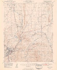
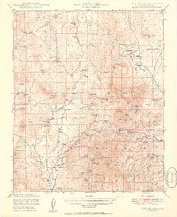
 1947 Prescott1959 Print · USGSArizona's territorial capital region is captured here in the late 1940s as the town expands toward the high desert. Genealogists and researchers can trace the limits of the Whipple Military Reservation, locate the Cem in Miller Valley, and follow the Atchison Topeka and Santa Fe rail line.3 unique versions available
 - 1948 Map of Iron Springs
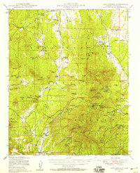
 1948 Iron Springs1948 Print · USGSIn the high country of Yavapai County in the late 1940s, ranching and the railroad shaped life from the peaks to the valleys. Genealogists and researchers can trace family landmarks like Rancho Moana, identify the remote Boston Arizona Mine, and locate the Tonto Springs Ranger Sta.
 - 1948 Map of Prescott
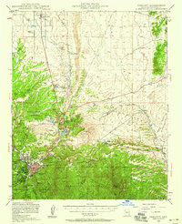
 1948 Prescott1948 Print · USGSPrescott and the surrounding Yavapai County highlands are shown here in the late 1940s as a bustling hub of mining, military presence, and rail transport. Researchers can trace historic landmarks like the Whipple Military Reservation, the Iron King Mine, and the Fain Ranch.4 unique versions available
 - 1949 Map of Iron Springs
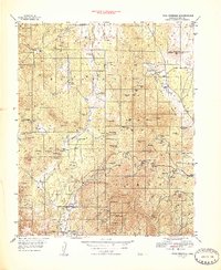
 1949 Iron Springs1949 Print · USGSYavapai County's high-country ranches and mines are meticulously mapped here in the late 1940s, just after the war. Local historians can trace old homesteads like American Ranch and Poley Ranch, or locate workings at the Gold Star Mine.2 unique versions available
End of results
Showing maps 1-5 of 5
Top cities near Prescott
- Prescott Valley historical maps
- Williamson historical maps
- Dewey-Humboldt historical maps
- Wilhoit historical maps
- Chino Valley historical maps
Top neighborhoods of Prescott
Frequently asked questions
- What are the different types of historical maps available for Prescott?
- What is the oldest map of Prescott?
- Where can I purchase historical maps of Prescott for my home or office?
- Where can I download high-res historical maps of Prescott?
- Are there historical topographic maps available for Prescott?
- Is there historical aerial imagery available for Prescott?
- Where are historical maps of Prescott sourced from?