1940s Maps of Wood Trap, Arizona
Explore 2 historic maps of Wood Trap from the 1940s. These maps offer a rare glimpse into what life looked like during the 1940s — showing old roads, neighborhoods, homes, and landmarks that have changed or disappeared over time.
Whether you're researching your family's past, planning a metal detecting trip, or studying how Wood Trap's landscape evolved across the 1940s, these high-resolution maps are a powerful tool for exploring the history of this region.
- Focus on a specific era: All maps on this page are from the 1940s, giving you a focused view of this time period.
- See what’s changed: Compare century-old streets, trails, and buildings to today's modern landscape using overlays and satellite layers.
- Research with precision: Use these maps for genealogy, historical research, land use analysis, or educational projects.
- View, download, or print: Maps are fully viewable online in high resolution, and can be downloaded or printed for your own records.
Start exploring Wood Trap's history through authentic maps from the 1940s. This is your window into the past.
Wood Trap, AZ maps
(2)- 1947 Map of Sheridan Mountain, 1960 Print
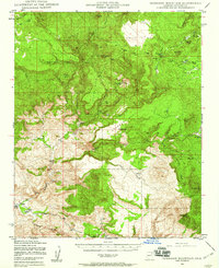 1947 Sheridan Mountain1960 Print · USGSThe high mesas and ranching outposts of Yavapai County are captured here in the late 1940s. Genealogists and historians can trace old cattle-country landmarks like Dumbbell Ranch, Yolo Cabin, and the sprawling Prescott National Forest.3 unique versions available
 - 1948 Map of Sheridan Mountain
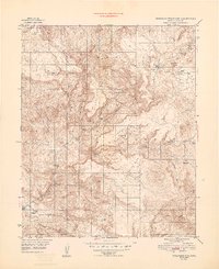 1948 Sheridan Mountain1948 Print · USGSIn the late 1940s, this area of the Yavapai highlands was a remote ranching frontier defined by isolated outposts. Researchers can trace historic family-named locations and water sources like Dumbbell Ranch, Yolo Cabin, and Willow Spring.
End of results
Showing maps 1-2 of 2
Top cities near Wood Trap
Frequently asked questions
- What are the different types of historical maps available for Wood Trap?
- What is the oldest map of Wood Trap?
- Where can I purchase historical maps of Wood Trap for my home or office?
- Where can I download high-res historical maps of Wood Trap?
- Are there historical topographic maps available for Wood Trap?
- Is there historical aerial imagery available for Wood Trap?
- Where are historical maps of Wood Trap sourced from?