1960s Maps of San Luis, Arizona
Explore 5 historic maps of San Luis from the 1960s. These maps offer a rare glimpse into what life looked like during the 1960s — showing old roads, neighborhoods, homes, and landmarks that have changed or disappeared over time.
Whether you're researching your family's past, planning a metal detecting trip, or studying how San Luis's landscape evolved across the 1960s, these high-resolution maps are a powerful tool for exploring the history of this region.
- Focus on a specific era: All maps on this page are from the 1960s, giving you a focused view of this time period.
- See what’s changed: Compare century-old streets, trails, and buildings to today's modern landscape using overlays and satellite layers.
- Research with precision: Use these maps for genealogy, historical research, land use analysis, or educational projects.
- View, download, or print: Maps are fully viewable online in high resolution, and can be downloaded or printed for your own records.
Start exploring San Luis's history through authentic maps from the 1960s. This is your window into the past.
San Luis, AZ maps
(5)- 1961 Map of El Centro
 1961 El Centro1961 Print · USGSThe California-Arizona borderlands come alive in this early sixties record of desert irrigation and military expansion. Genealogists and researchers can trace the engineering of the All American Canal and locate vanished sites like Araz and the Imperial County Tuberculosis Sanatorium.
 - 1964 Map of El Centro
 1964 El Centro1964 Print · USGSThe agricultural heart of the California desert and the military test ranges of Arizona are revealed in this mid-century study. Genealogists and historians can trace the paths of the Southern Pacific railroad and the All American Canal near El Centro and Yuma.
 - 1964 Map of South of Yuma, 1966 Print
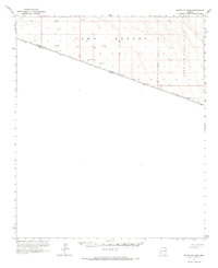 1964 South of Yuma1966 Print · USGSThe international border in the mid-1960s reveals a sparse landscape defined by the Yuma Desert. Researchers can trace the United States-Mexico line past several Test Wells and the edge of the Luke Air Force Range.
 - 1965 Map of Somerton, 1966 Print
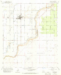 1965 Somerton1966 Print · USGSIn the mid-1960s, the irrigation grid surrounding Somerton transformed the arid valley into a productive agricultural landscape. Researchers can trace the layout of Yuma Indian Homesteads and find early aviation sites like Somerton Airport.2 unique versions available
 - 1965 Map of Gadsden, 1966 Print
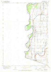 1965 Gadsden1966 Print · USGSThe Arizona-Mexico borderlands come into sharp focus in the mid-1960s, showing a landscape defined by the Colorado River and complex irrigation. Genealogists and historians can trace the development of Gadsden and San Luis alongside the Southern Pacific and South Main Canal.2 unique versions available
End of results
Showing maps 1-5 of 5
Top cities near San Luis
- Yuma historical maps
- Somerton historical maps
- Donovan Estates historical maps
- Gadsden historical maps
- Rancho Mesa Verde historical maps
- Orange Grove Mobile Manor historical maps
See more
Top neighborhoods of San Luis
- Escondido Beach historical maps
- Frontera Estates historical maps
- Los Alamos historical maps
- Rio Sereno historical maps
- Las Brisas de San Luis historical maps
- Los Olivos historical maps
See more
Frequently asked questions
- What are the different types of historical maps available for San Luis?
- What is the oldest map of San Luis?
- Where can I purchase historical maps of San Luis for my home or office?
- Where can I download high-res historical maps of San Luis?
- Are there historical topographic maps available for San Luis?
- Is there historical aerial imagery available for San Luis?
- Where are historical maps of San Luis sourced from?